Shetlands Tail - ACE-High-Journal
Hauptmenü:
×
- Start Seite, WebSite
-
ACE-High System, Informationen
- ACE-High, WebSite Index
- Der Kalte Krieg
- ACE-High Network
- ACE-High Network France, die Geschichte
- ACE-High Station Feldberg, ein Zeitdokument
- ACE-High Station Feldberg, Karlsruhe 2.tes Meeting
-
NATO Kommunikation
- Cemetery Network
- Cronos
- DCS
- Double Jump
- Jocas
- NICS
- NTTS
- Last talk
-
Nationale Systeme
- BEMILCOM (Belgien)
- ASCON (Niederlande)
- NAFIN (Niederlande)
- DITSN (Italien)
-
NTTS (Italien)
- Info Seite, NTTS System
- FTASE, Alliierte Landstreitkräfte Südeuropas
- Nationaler Linienplan
- Affi, Bunker West Star, Site B
- Aviano, Air Base
- Brescia, Monte Maddalena, Site D
- Cansiglio, Site G
- Cavriana
- Collio, Dosso dei Galli
- Comano, Livorno
- Comerlati, Monte Comerlati, Site W
- Comiso, Air Base
- Concordia Sagittaria, Lame Concordia
- Crosara, Monte Alto, Site E
- Ghedi, Air Base
- Grezzana, Bunker Back Yard, Site A
- Lughenzzano, SatCom F14
- Milano
- Motta di Livenza
- Nisidia, Navy HQ NAVSOUTH
- Negrar, Monte Tondo
- Padua, Monte Venda
- Piacenza, Air Base
- Piancavallo, Site J
- Poggio Renatico
- Romano d`Ezzelino, La Gusella, Site F
- Site M (nicht aktiviert)
- Solbiate Olana
- Treviso-Istrana, Air Base
- Treviso-Sant Àngelo, Air Base
- Verona, Palazzo Carli
- Vicenza, Air Base, 5 ATAF
- Villafranca di Verona, Air Base
- Vittoria Veneto
- Volta Mantovana, Air Force, Site C
- PTT (Italien)
- 114F (Italien)
- 305 (Italien)
- Starrnet (U.K)
- NATO Verbandsabzeichen
- Linienführung
-
Technik
- Technik, Innenbereich
- Technik, Aussenbereich
- Technik, Komponenten
- Formblatt
- Handbücher
- No Break Unit
- Personal
- Warnungen
- Zeichnungen
- Impressum
-
Systeme vor dem ACE-High System
-
AIRCENT
- Info Seite, AIRCENT (1)
- Linienplan, AIRCENT
- Technik (Innen- und Aussenbereich)
- Fontainebleau (Camp AIRCENT HQ)
- A-1. Fontainebleau (Terminal-AIRCENT)
- A-2. Croix d'Augas
- A-3. Melun
- A-4. Jossigny
- A-4. Marly-le-Roi (Terminal-SHAPE)
- A-5. Éméville
- A-6. Margival (Crouy)
- A-6 / D-1. Margival (Laffaux)
- A-7 / D-2. St. Erme
- A-8 / D-3. Poix-Terron (La Bascule)
- B-3. Angevillers (Molvange, Bloc 7)
- Brassoir
- Brüssel-Evere, Terminal NATO HQ
- C-1. Lüttelforst
- C-2. Lammersdorf
- C-3. Roclenge-sur-Geer
- C-4. Baraque-de-Fraiture
- C-5. Vieux Moulins
- Chimay
- D-2. Jonchery-sur-Vesle
- D-4. Liart
- Haraumont
- Mönchengladbach (Terminal - 2. ATAF)
- Perl-Eft
- Plailly
- Trier-Euren (Mohrenkopf)
- Trier-Euren (Terminal Stab-4-ATAF)
-
Sonstige AIRCENT Stationen (2)
- Info Seite, AIRCENT (2)
- Bann
- La Fèrèe
- Mannheim-Seckenheim (Terminal)
- Marlemont
- Montlhèry
- Münchweiler
- Weiskirchen
-
LANDCENT
- Info Seite, LANDCENT (1)
- Linienplan, LANDCENT
- Technik (Innen-Aussenbereich)
- Bann (Kindsbach)
- Donnersberg
- Fontainebleau (Terminal B-La Madeleine)
- Mannheim-Seckenheim (Terminal B-CENTAG)
- Mönchengladbach (Terminal B-NORTHAG)
- Münchweiler
- R1. Dampleux
- R1 / R1. Marlemont
- R 2. La Haute-Maison
- R 2. Stonne
- R 3. Croix d'Augas
- R 3. Grandmenil
- R 3. Haraumont
- R 4. Angevillers (Bloc 7)
- R 4. Baraque Michel
- R 5. Perl-Eft
- R 6. Freisen
- Soissons (Terminal A)
- Weiskirchen
-
Sonstige LANDCENT Stationen (2)
- Info Seite, LANDCENT (2)
- Feschaux
- Fontainebleau (Camp Guynemer/LANDCENT HQ)
- Heidelberg HQ
- Le Mensil
- 2. Fontainebleau-Maintenace
-
AFCENT/JCA
- Info Seite, AFCENT/JCA (1)
- Linienplan, AFCENT/JCA
- Technik (Innen- Aussenbereich)
- 1- Fontainebleau, AFCENT HQ
- 2. Fontainebleau-Maintenance
- 3. Saint-Méry-Bombon
- 4. Bussières (La Haute-Maison)
- 4. La Haute-Maison
- 5. Dampleux
- 6. Lagery
- 7. St. Erme
- 8. Jossigny
- 9. Éméville
- 10. Margival (Laffaux)
- 11. Wahlhausen (ex 24)
- 12. La Bascule
- 13. Haraumont
- 14. Angevillers
- 15. Weiskirchen
- 16. Bann (Kindsbach)
- 17. Münchweiler
- 18. Marlemont
- 19. Vieux Moulins (AFCENT Site)
- 20. Baraque-de-Fraiture
- 21. Maastricht
- Maastricht-Kanne (Bunker Cannerberg)
- 21. Roclenge-sur-Geer
- 22. Lammersdorf
- 23. Mönchengladbach (Rheindahlen)
-
Sonstige AFCENT/JCA Stationen (2)
- Info Seite, AFCENT/JCA
- Prüm-Air Station (AS)
-
AFCENT/CRICS
- Info Seite, AFCENT/CRICS
- Linienplan, AFCENT/CRICS
- Baraque Michel
- Baraque-de-Fraiture
- Brunssum
- Erbeskopf
- Hornisgrinde
- Kindsbach
- Maastricht, "CENTAG"
-
Baraque Michel
- Maastrichr, "LCO"
- Pirmasens
- Prüm-Post
-
AIRCENT
-
Systeme mit dem ACE-High System
-
DEW System
- Info Seite, DEW
- Linienplan, DEW
- DYE-5, Keflavik
- DYE-4, Kulusuk
-
NARS System
- Info Seite, NARS
- Linienplan, NARS
- Faröer, Site 43
- Flyingdales, Site 46
- Höfn, Site 42
- Keflavik, Site 41
- Mormond Hill, Site 44
-
DEW System
-
ACE-High System
- Info Seite, ACE-High System
-
Bereich, ACCHAN
-
England
- Info Seite, ACCHAN
- Linienplan, ACCHAN
- Aberdeen
- Aberdeen Tail
- Binbrook
- Boulmer
- Faroes
- London
- London Tail
- London Tail Relay
- Shetlands
- Shetlands Tail
- Shetlands Tail Relay
-
England
-
Bereich, AFNORTH
-
Dänemark
- Info Seite, AFNORTH
- Linienplan, AFNORTH
- Kollemorten
- Lundebakke
-
Norwegen
- Info Seite, AFNORTH
- Linienplan, AFNORTH
- Konferenz, AFNORTH
- Bodø
- Bodø Tail
- Kolsås
- Høggumpen
- Kristiansand
- Lysenut
- Mågerø
- Mosjøen
- Oslo
- Senja
- Svartås
- Trondheim
- Trondheim Tail
-
Dänemark
-
Bereich, AFCENT
-
Belgien
- Info Seite, AFCENT
- Linienplan, AFCENT
- Adinkerke
- Baraque-de-Fraiture
- Casteau (SHAPE)
- Chievres
-
Deutschland
- Info Seite, AFCENT
- Linienplan, AFCENT
- Aurich
- Feldberg
- Hehn
- Kindsbach
- Lammersdorf
- Moenchen-Gladbach, Teil (2) (Millen)
- Uedem
-
Frankreich
- Info Seite, AFCENT
- Linienplan, AFCENT
- Éméville
- Lyon
- Nice
- Paris North
- Paris South
- Paris Tail (1), Laffaux
- Paris Tail (2), Extension-SHAPE
- Paris Tail (2), St. Germain
- Paris, Tour Eiffel control center
- Rohrbach
- Rozoy-Bellevalle
- Taverny
-
Niederlande
- Info Seite, AFCENT
- Linienplan, AFCENT
- Brunssum
- Maastricht
-
Belgien
-
Bereich, AFSOUTH
-
Griechenland
- Info Seite, AFSOUTH
- Linienplan, AFSOUTH
- Athens
- Athens Tail
- Ismaros
- Kefallonia
- Larissa
- Larissa Tail
- Vitsi
- Ziros
-
Italien
- Info Seite, AFSOUTH
- Linienplan, AFSOUTH
- Aviano Lame Tail
- Catanzaro
- Cavriana
-
Dosso dei Galli
- Dosso dei Galli (1)
- Dosso dei Galli (2)
- Beschreibung (Deutsche-Version)
- Beschreibung (Versione-italiana)
- Bilddokumentationen 1969>1974
- Bilddokumentationen 1975>2004
- Bilddokumentationen 2005>2009
- 2009, Anniversary 40 Jahre
- Bilddokumantationen 2010>2019
- 2019, Anniversary 50 Jahre
- Bilddokumentationen 2020>heute
- Publikationen
- Lame Concordia
- Latina School
- Livorno
- Malta (Gharghur)
- Malta (Floriana)
- Martina Franca
- Monte Iacotenente
- Monte Lauro
- Monte Petrino
- Monte Vergine
- Monte Vulture
- Naples
- Pietra Ficcata
- Rome
- Rome Tail
- Verona Tail
- Verona Torre 4
-
Türkei
- Info Seite, AFSOUTH
- Linienplan, AFSOUTH
- Adana
- Adana Tail
- Amasra
- Ankara
- Ankara Tail
- Cyprus
- Diyarbakir
- Diyarbakir Tail (Air Base)
- Eskisehir
- Eskisehir Tail
- Izmir
- Izmir Tail
- Mardin
- Merzifon
- Pazar
- Persembe
- Sivas
-
Griechenland
-
Sonstige Objekte
-
Gedenkstätten, Museen
-
Belgien
- Info Seite, Gedenkstätten, Museen
- Adinkerke, Kriegsgräber
- Adinkerke, Museum Cabour WK II
- Elsenborn, Truschbaum Museum
- Grandemènil, Denkmal
- Grandemènil, Panther G
- Joubiéval, Museum
- Kanne, Flieger Denkmal
- Kanne, Kriegsgräber
- Kanne, Denkmal 1940
- Leoboldsburg, Kriegsgräber
- Poteau, 44 Museum
-
Deutschland
- Info Seite, Gedenkstätten, Museen
- Hehn-Heiligenpesch, Wallfahrtort
- Heimbach, Ehrenfriedhof Mariawald
- Hürtgen, Kriegsgräber
- Marienborn-Helmstedt, Gedenkstätte
- MG-Rheindahlen, Military Cemetery
- Peenemünde, Museum
- Pütnitz, Technik Museum
- Sinsheim, Technik Museum
- Viersen-Süchteln, Kriegerdenkmal
- Vossenack, Kriegsgräber
- Waldniel, Gedenkstätte I
- Waldniel, Gedenkstätte II
-
Frankreich
- Info Seite, Gedenkstätten, Museen
- Belleau, Le Bois Belleau, Kriegsgräberstätte
- Belleau, Kriegsgräberstätte
- Château-Thierry, Cote 204
- Compiègne, Gedenkstätte
- Douaumont, Gedenkstätte
- Mondement-Montgivroux, Memorial
- Montmirail, Monument Napoleon
- Soizy aux Bois, Kriegsgräberstätte
- Valmy-Quartier Douenc, Historische Stätte
- Vauxbuin, Kriegsgräberstätte
- Verdun, Memorial de Verdun
- Verdun-Bevaux, Kriegsgräberstätte
-
Belgien
-
Militärische Objekte
-
Belgien
- Air Base, Flughafen
-
Munitionslager, Sonderwaffenlager
- Info Seite, Munitionslager
- Houthulst
-
Richtfunk
- Info Seite, Richtfunk
- Info Seite, BeMilCom
- Adinkerke, Site 080
- Arlon, Site Kaserne Callemeyn
- Battice, Site 024
- Ben-Ahin, Site Mx
- Brüssel-Evere, Terminal NATO HQ
- Court-Saint-Etienne
- Court-Saint-Etienne, Site Mx
- D`Hoppe, Site Mx
- Elsenborn, Site Camp Elsenborn
- Eupen
- Everberg, Site 115
- Genk
- Hannut, Site 055
- Houthulst
- Kester-Heide, Site Mx
- Kester-Heide, Site 251
- Latin, Site Mx
- Millen, Site Mx
- Millen, Site 056
- Molenbeek, Site Mx
-
TrÜbPl, Kasernen
- Info Seite, TrÜbPl, Kasernen
- Elsenborn, Camp Elsenborn
- Leopoldsburg, Camp Beverlo
-
WK I, Objekte
- Info Seite, WK I, Festungen
- Lüttich, Fort Barchon
- Lüttich, Fort Boncelles
- Lüttich, Fort Chaudfontaine
- Lüttich, Fort Embourg
- Lüttich, Fort Evegnèe
- Lüttich, Fort Flémalle
- Lüttich, Fort Flèron
- Lüttich, Fort Hollogne
- Lüttich, Fort Lantin
- Lüttich, Fort Liers
- Lüttich, Fort Loncin
- Lüttich, Fort Pontisse
-
WK II, Objekte
- Info Seite, WK II, Festungen
- Lüttich, Fort Aubin-Neufchâteau
- Lüttich, Fort Battice
- Lüttich, Fort Eben-Emael
- Lüttich, Fort Tancremont
- Vroenhoven, Brücken-Denkmal
-
Dänemark
-
TrÜbPI
- Info Seite, TrÜbPI
- Finderup, TrÜbPI Finderup
-
TrÜbPI
-
Deutschland
-
Air Base, Flughafen
- Info Seite, Air Base, Flughafen
- Baden-Söllingen, Air Base
- Geilenkirchen, Air Base
- Laarbruch, Air Base
- Lahr, Air Base
- Nörvenich, Air Base
-
FlaRak
-
FlakRak, Hawk
- Info Seite, Hawk
- Deutschland
- FlaRak, Nike-Herkules
- FlaRak, Pershing
-
FlakRak, Hawk
-
GSVBw
- Info Seite, GSVBw
- Sankt Martin, Bunker "GSVBw44"
-
Kasernen
- Info Seite, Kasernen
- Altenwalde, Hinrich-Wilhelm-Kopf-Kaserne
- Bad Bergzabern, Mackensen Kaserne
- Borgenstreich, Desenberg Kaserne
- Clausthal-Zellerfeld, Oberharz-Kaserne
- Düren, Belgische Panzer Kaserne
- Erndtebrück, Hachenberg Kaserne
- Euskirchen, Mercator Kaserne
- Freising, General-von-Stein-Kaserne
- Freising, Vimy-Kaserne
- Karlsruhe, General-Fahnert-Kaserne
- Köln, Luftwaffenkaserne
- Lauda, Tauberfranken Kaserne
- Meßstetten, Zollernalb-Kaserne
- Mönchengladbach, Niederrhein Kaserne
- Oldenburg, Donnerschwee Kaserne
- Rendsburg, Eider-Kaserne
- Seebach, Hornisgrinde Kaserne
- Trier-Euren, General-von-Seidel-Kaserne
- Ulm, Wilhemsburg Kaserne
- Varel, Friesland Kaserne
-
Munitionslager, Sonderwaffenlager
- Info Seite, Munitionslager
- Fischbach, Area One
- Geilenkirchen, Atomwaffenlager
- Geilenkirchen, Munitionslager
- Gemünd, Munitionslager
-
NVA, Objekte
- Info Seite, NVA Objekte
- Binz, Prora
- Börgerende, Grenzturm
- Kühlungsborn, Grenzturm
- Lindholz, Bunker 302 (Eichenthal)
- Prerow, alte Liegenschaft
- Prerow, Darßer Ort, Stellung
- Prerow, Darßer Ort, Fernmelde Verteiler
- Zingst, Truppenübungsplatz
- Zingst, Wasserbunker
-
Polygone, Objekte
- Info Seite, Polygone Objekte
- Bann, Site Alpha
- Bann, Site Bravo
- Breitenbach
- Pirmasens-Husterhöhe
- Salzwoog
- Zweibrücken-Oberauerbach
-
Richtfunk
- Info Seite, Richtfunk
- Altenwalde
- Bad Bergzabern, Sauhäusel
- Bitburg, Air Base
- Eschers-Untrasried
- Feldberg (Schwarzwald)
- Freudenstadt, Alexanderschanze
- Geilenkirchen, Air Base
- Lahr, Air Base
- Leimen-Christelseck
- Maikammer, Kalmit
- Prerow, Darßer Ort
- Rettersen
- Schöneberg
- Schwagsdorf
- Seebach (Hornisgrinde)
- Spangdahlem, Air Base
-
TrÜbPl
- Info Seite, TrÜbPI
- Baumholder, TrÜbPI Baumholder
- Eckersweiler, Aussenfeuerstelle Nr 205
- Gemünd, Camp Vogelsang
- Gemünd, TrÜbPl Vogelsang
- Gemünd, TrÜbPl Vogelsang Dorf Wollseifen
- Gemünd, "Igel Stellung"
- Hitfeld, Camp Hitfeld
- Meßstetten, TrÜbPl Heuberg
-
U.S. Objekte
- Info Seite U.S. Objekte
- Bann, Site Alpha
- Bann, Site Charly
- Bitburg, Air Base
- Darmstadt, Army Air Field
- Friolzheim, Radio Relay Site 12
- Geigenwang, Radio Relay Site 16A "Chrysler"
- Heidelberg, Campbell Barracks
- Hofstätten, Radio Relay Site 101 "Langerkopf"
- Mannheim, Hammonds Barracks
- Maßweiler, Bunker Cave 7921
- Pirmasens, Army Depot Site 17
- Pirmasens, Husterhoeh Kaserne
- Sembach, Air Base
- Spangdahlem, Air Base
- Ramstein, Air Base
- Stocksberg
- Stuttgart-Burgholzhof, Robinson Barracks
- Stuttgart-Vaihingen, Patch Barracks
-
WK II, Objekte
- Info Seite, WK II, Objekte
- Aurich, Flakstellung
- Paustenbach, Eifelkreuz
-
WK II, Westwall
- Westwall, Übersicht Festungsabschnitte
-
Aachen-Saar Programm
- Westwall, Übersicht, Aachen-Saar
- Bad Bergzabern, Westwall Museum
- Simonskall, Sanitätsbunker
- Schmithof, Höckerlinie
- Lammersdorf, Höckerlinie
- Langschoß, Wasserbunker
- Vossenack, Hürtgenwald Museum
-
Ettlinger Riegel
- Westwall, Übersicht, Ettlinger Riegel
- in Vorbereitung
-
Geldernstellung
- Westwall, Übersicht, Geldernstellung
- in Vorbereitung
-
Isteiner Klotz
- Westwall, Übersicht, Isteiner Klotz
- in Vorbereitung
-
LVZ-West
- Westwall, Übersicht, LVZ-West
- Bad Münstereifel, FHQ "Felsennest"
- Kniebis, FHQ "Tannenberg"
- Seebach (Hornisgrinde), LVZ-West Stellung
- Seebach (Schliffkopf), LVZ-West Stellung
-
Orscholzriegel
- Westwall, Übersicht, Orschozriegel
- Pirmasens-Niedersimten, Museum Gerstfeldhöhe
-
Air Base, Flughafen
-
Frankreich
-
Polygone, Objekte
- Info Seite, Polygone Objekte
- Chenevières, Site 03
- Èpinal, Site 01
- Grostenquin, Site 02
-
TrÜbPI, Kasernen
- Info Seite, TrÜbPI, Kasernen
- Angevillers, Camp d`Angevillers
- Margival, Camp de Margival, AFCENT WHQ
-
WK I, Objekte
- Info Seite , WK I, Objekte
- Contè-sur-Aisne, Fort Contè
- Duzey, Canon Allemand
- Verdun, Fort de Douaumont
- Verdun, Fort de Souville
- Verdun, Fort de Vaux
-
WK II, Objekte
- Info Seite, WK II, Objekte
- Rochonvillers, Anlage "Brunhilde"
-
WK II, Maginot Line
- Übersichtsplan, Maginot
-
8 Secteur Fortifiè de la Crusnes
- Übersicht, 8 S.F.
- Info Seite, 8 S.F.
- Gros Ouvrage Fermont
-
9 Secteur Fortifiè de Thionville
- Übersicht, 9 S.F.
- Info Seite, 9 S.F.
- Abri du Grand Lot
- Camp d`Angevillers
- Casemate d`Escherange Ouest
- Casemate du Grand Lot
- Abri de tir (du petit Lot, 1)
- Abri de tir (du petit Lot, 2)
- Gros Ouvrage Rochonvillers Bloc 1 > 8
- Gros Ouvrage Rochonvillers Bloc 9
-
10 Secteur Fortifiè de Boulay
- Übersicht, 10 S.F.
- Info Seite, 10 S.F.
- Gros Ouvrage Hackenberg
- Gros Ouvrage Michelsberg
- Abri de Bilmette
- Blockhaus Bb 9
- Gros Ouvrage Mont des Welches
- Abri de Mont des Welches
- Abri d`Ising
-
12 Secteur Fortifiè de la Sarre
- Übersicht, 12 S.F.
- Info Seite, 12 S.F.
- Petit Ouvrage Haute-Poirier
- von Bettviller nach Achen
-
13 Secteur Fortifiè de Rohrbach
- Übersicht, 13 S.F.
- Info Seite, 13 S.F.
- Gros Ouvrage Simserhof
- Casemate du Lègeret
- Casemate Bining
- Abri de tir, Biningerwiese
- Petit Ouvrage Rohrbach (Fort Casso)
- Petit Ouvrage Welschhof
-
14 Secteur Fortifiè des Vosges
- Übersicht, 14 S.F.
- Info Seite, 14 S.F.
- Gros Ouvrage du Four-à-Chaux
-
15 Secteur Fortifiè de Haguenau
- Übersicht, 15 S.F.
- Info Seite, 15 S.F.
- Abri de tir de Birlenbach
- Casemate de Bremmelbach Nord
- Casernement de Drachenbronn
- Gros Ouvrage de Hochwald Est
- Gros Ouvrage de Hochwald Ouest
- Abri de Hatten
- Abri de tir Hatten
- Casemate d`Ingolsheim Est
- Casemate d`Ingolsheim Ouest
- Casemate Esch
- Casemate la Selz
- Observatoire de Hatten
- Gros Ouvrage Schoenenbourg
- Abri de tir Pfaffenschlick Sud
- Casemate du Bois de Rittershoffen 1
- Casemate du Bois de Rittershoffen 2
- Casemate du Bois de Rittershoffen 6
-
Polygone, Objekte
-
Italien
-
Grande Guerra, Objekte
- Info Seite, Grande Guerra
- Anfo, Forte Clima Ora
- Lubiara, Forte San Marco
- Maniva, Caserma Casaliti (Locanda Bonardi)
- Maniva, Caserma Casermone
- Maniva, Caserma Giogo Bala
- Maniva, Giogo del Maniva
- Pastrengo, Forte Bendeck
- Pastrengo, Forte Degenfeld
- Pastrengo, Forte Nugent
- Pastrengo, Forte Leopold
- Pastrengo, Telegrafo Ottico
- Rivoli Veronese, Forte d`Tagliata d' Incanal
-
Munitionslager, Sonderwaffenlager
- Info Seite, Munitionslager
- Ghedi, Atomwaffenlager
-
TrÜbPI, Kasernen
- Info Seite, TrÜbPI, Kasernen
- Verona, Caserma Busignani
- Verona, Caserma Li Gobbi
-
Grande Guerra, Objekte
-
Niederlande
-
TrÜbPl, Kasernen
- Info Seite, TrÜbPl, Kasernen
- Maastricht, Tabijn Kaserne
-
TrÜbPl, Kasernen
-
Österreich
-
WK I, Objekte
- Info Seite, WK I, Objekte
- Festung Nauders
-
WK I, Objekte
-
Schweiz
-
WK II, Objekte
- Info Seite, WK II, Objekte
- Airolo, Artilleriewerk Airolo
- Airolo, Artilleriewerk Foppa Grande
- Airolo, Artilleriewerk San Carlo
- Airolo, Artilleriewerk Sasso da Pigna
- Airolo, Hospizwerk Gottardo
-
WK II, Objekte
-
Belgien
-
Zivile Objekte
-
Deutschland
- Info Seite, Zivile Objekte
- Bad Münstereifel, Effelsberg, Radioleleskop
- Bad Münstereifel, Stockert, Astropeiler
- Calmbach, Klinik Chalottenhöhe
- Dannenfels, Ludwigturm
- Feldberg, Schwarzwald
- Feldberg, Taunus
- Kniebis, Hotel Alexanderschanze
- Langschoß, Feuerwachtturm
- Maikammer, Kalmit
- Mönchengladbach, Verkehrslandeplatz
- Mülheim, Verkehrslandeplatz
- Schwalmtal, Fabrikanlage
- Viersen-Süchteln, Irmgardiskapelle
- Viersen-Süchteln, Historischer Wasserspeicher
- Weeze, Schloss Wissen
-
Deutschland
-
Zivile Bunker
-
Dänemark
- Info Seite, Zivile Bunker
- Regan Vest
-
Deutschland
- Info Seite, Zivile Bunker
- Meerbusch, Hochbunker "Böhler"
- Mönchengladbach, Lürriper Strasse
- Satzvey, Sonderbauwerk "Steinfurt"
- Staffel, Postbunker "Sonderbetriebsstelle Kesseling 0"
-
Dänemark
-
Ziviler Richtfunk
-
Belgien
- Info Seite, Richtfunk
- Elst
- Frameries
- Hannut, Site RTB
- Oostvleteren
- Ypern
-
Deutschland
- Info Seite, Richtfunk
- Liste der Typentürme
- Baden-Baden, Merkurturm
- Bambergerhof, BNetzA Peiler
- Bielefeld (Hünenburg)
- Bremen-Walle, FMT
- Bremen-Woltmershausen
- Brocken
- Clenze (Clenze 1)
- Dieblich-Naßheck, Sender Koblenz
- Düsseldorf, Rheinturm
- Feldberg (Schwarzwald), SWR Sender
- Gernsbach, Hohloh
- Gollenberg
- Grevenbroich, Vollrather Höhe
- Großhau, FMT
- Holzminden, Köterberg
- Gartow (Höbeck)
- Kniebis
- Lauschied
- Lübbecke
- Mönchengladbach, FMT
- Nettetal-Hinsbeck
- Nottuln, WDR Sender
- Ober-Abtsteinach, HR Sender
- Reichweiler, FMT
- Schömberg, Sender Langenbrand
- Schöneberg, FMT
- Seebach (Hornisgrinde), SWR Sender
- Seebach (Hornisgrinde), Transmitter (Mobilfunk)
- Seebach (Hornisgrinde), Telekom
- Sulzbach-Rosenberg
- Sulzbach-Rosenberg, Transmitter (Mobilfunk)
- Torfhaus
- Viersen-Bockert
- Viersen-Süchteln, FMT
- Waldböckelheim
- Wallhausen, Transmitter (Mobilfunk)
- Wehrheim, Roßkopf
- Wildeshausen
- Willich-Schiefbahn, FMT
- Würselen, Transmitter (Mobilfunk)
-
Deutschland (Berlin)
- Info Seite, Richtfunk Berlin
- Berlin-Britz
- Berlin-Frohnau
- Berlin-Köpenick, Müggelberge
- Berlin-Köpenick, Sender Berlin-Köpenick
- Berlin-Mitte, Fernsehturm
- Berlin-Nikolasee
- Berlin-Schöneberg
- Berlin-Wannsee, Erdfunkstelle
- Berlin-Wannsee, Schäferberg (Berlin 3)
- Berlin-Westend, Funkturm
- Berlin-Westend, Scholzplatz
- Berlin-Westend, Stallupöner Allee
- Berlin-Zehlendorf
-
Frankreich
- Info Seite, Richtfunk
- Le Bois de Molle
- Wissembourg, Eselberg
- Wissembourg, Klingfeld
-
Schweiz
- Info Seite, Richtfunk
- Arth-Goldau, Rigi Kulm
-
Belgien
-
Gedenkstätten, Museen
-
Sonstige Systeme
-
BARS "БАРС" Schneeleopard
- Info Seite, BARS
- Übersichtsplan, BARS
- Lindholz, Bunker 302 (Eichenthal)
-
BAOR/RAF Germany
- Info Seite, BAOR/RAF
- Übersichtsplan, BAOR/RAF
- Arsbeck
- Bielefeld (Ebberg)
- Bielefeld (Hünenburg)
- Birgelen
- Brüggen
- Deister (Annaturm)
- Dörenberg (BFBS)
- Groß Gusborn (BFBS)
- Hehn
- Hostert, Britisch Military Hospital
- Krefeld
- Lübbecke ridge BFBS Transmitter (Holsen)
- Mönchengladbach
- Roetgen (Lammersdorf)
- Schwalmtal, HQ NAAFI Waldniel
- St.Tönis, Francisca Barracks
- Weeze-Laarbruch, RAF Air Base
- Wegberg, RAF Hospital
- Wildenrath, RAF Air Base
- Willich, Kitchener Barracks
-
Echolon Netzwerk
- Info Seite, Echolon
- Ayios Nikolaos Station, Cyprus
- Bad Aibling
- Berlin, Teufelsberg
-
ET-A System
- Info Seite, ET-A
- Linienplan, ET-A
-
Belgien
- Info Seite, Belgien
- Ben-Ahin
- Casteau
- Chièvres
- Flobecq
- Houtem
- Le Chenoy
- Spa-Malchamps
- Westrozebeke
-
Deutschland
- Info Seite, Deutschland
- Adenau (Raßberg)
- Berlin, Dahlem
- Berlin, Marienfelde
- Berlin, Olympiastation
- Berlin, Schäferberg
- Berlin, Tempelhof
- Berlin, Teufelsberg
- Bocksberg
- Breitsol
- Bremerhaven (Carl-Schurz Kaserne)
- Donnersberg
- Feldberg (Schwarzwald)
- Feldberg (Taunus)
- Heidelberg
- Hohenpeissenberg
- Hohenstadt
- Holzminden, Köterberg
- Linderhofe
- Munich
- Nuernberg
- Schönfeld (Prüm Air)
- Stein
- Wunstorf, Air Base
- Zugspitze
-
England
- Info Seite, England
- Martlesham Heath
- RAF Fylingdales
-
Frankreich
- Info Seite, Frankreich
- Camp Bussac
- Dreux-Louvilliers, Air Base
- Maison Fort
- Nancy, Emergency Airfield
- Paris (Camp des Loges)
- Vatry, Air Base
-
Niederlande
- Info Seite, Niederlande
- Hoeck van Holland
-
RAF UK > BAOR, Scatterlink
- Info Seite, Scatterlink
- Linienplan, Scatterlink
- Roetgen (Deutschland)
- Swingate (England)
-
Royal Air Force, UK
- Info Seite, RAF UK
- Linienplan, RAF UK
- Bulbarrow Hill
- Dean Hill
- Fylindales Moor
- Golden Pot Towers
- High Wycombe Air Base
- HQ Northwood
-
Royal Air Force, Cyprus
- Info Seite, RAF Cyprus
- Linienplan, RAF Cyprus
- Akrotiri
- Akrotiri, Dekalia
- Ayios Nikolaos Station
- Cyta Yeroskipos
- Lincolnshire Poacher
- Troodos
-
Medcom System, 486L
- Info Seite, 486L Medcom
- Linienplan, 486L Medcom
-
England
- Info Seite, England
- Ringstead Bay
-
Griechenland
- Info Seite, Griechenland
- Levkas, Site 14B
- Mount Edheri, Site 24D
- Mount Pateras, Site 15H
-
Italien
- Info Seite, Italien
- Cima Gallina, Site 120
- Cima Grappa
- Cima Paganella
- Coltano, Site 9L
- Martina Franca, Site 7A
- Monte Cimone
- Monte Corna
- Monte Limbara, Site 4C
- Monte Nardello, Site 6E
-
Monte Vergine, Site 5F
- Monte Vergine, Site 5F
- Padua, Monte Venda
- Savona, Site 56
- Sigonella
-
Spanien
- Info Seite, Spanien
- Gorramendi, Site 163
- Guardamar, Site 33
- Humosa, Site 1A
- Inogès, Site 21
- Menorca, Site 3B
- San Pablo, Site 108
- Mallorca, Site 3H
-
Türkei
- Info Seite, Türkei
- Adana, Site 129
- Balikesir, Site 32
- Elmadağ, Site 142
- Malatya, Site 105
- Şahin Tepesi, Site 30G
- Samsun, Site 137
- Sinop, Site 121
- Yamanlar, Site 16D
-
BARS "БАРС" Schneeleopard
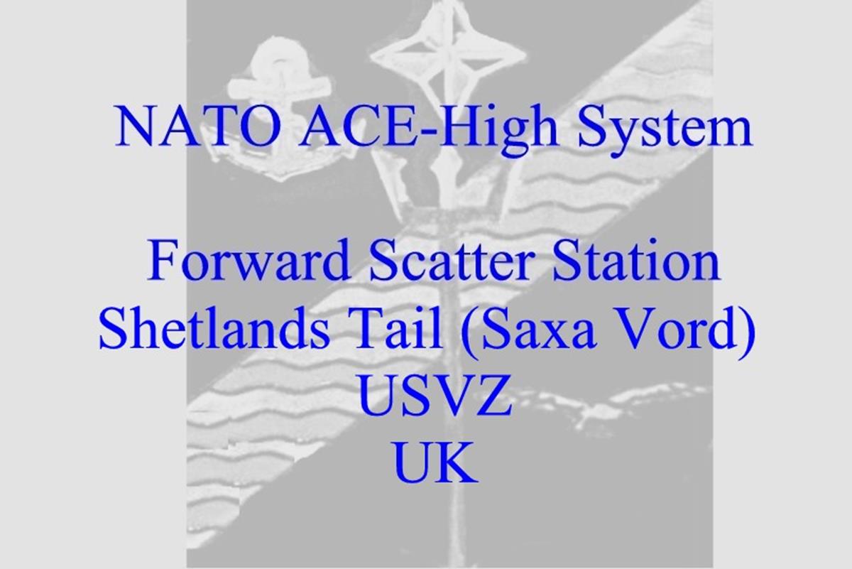
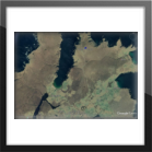
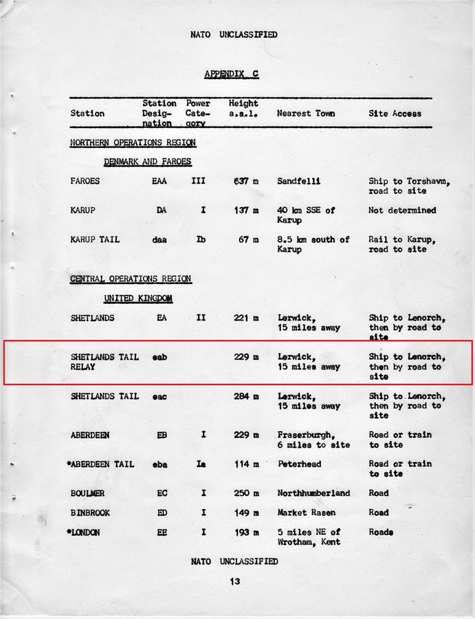
ACE-High System > Bereich, ACCHAN > England > Shetlands Tail
ACE-High System von 1958 bis 1995
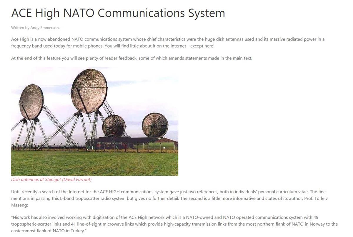
ACE-High System (Allied Command Europe Tropospheric Forward Scatter Communications Systems)
______________________________________________________________________________________________________________________________________________________________________________________________________________
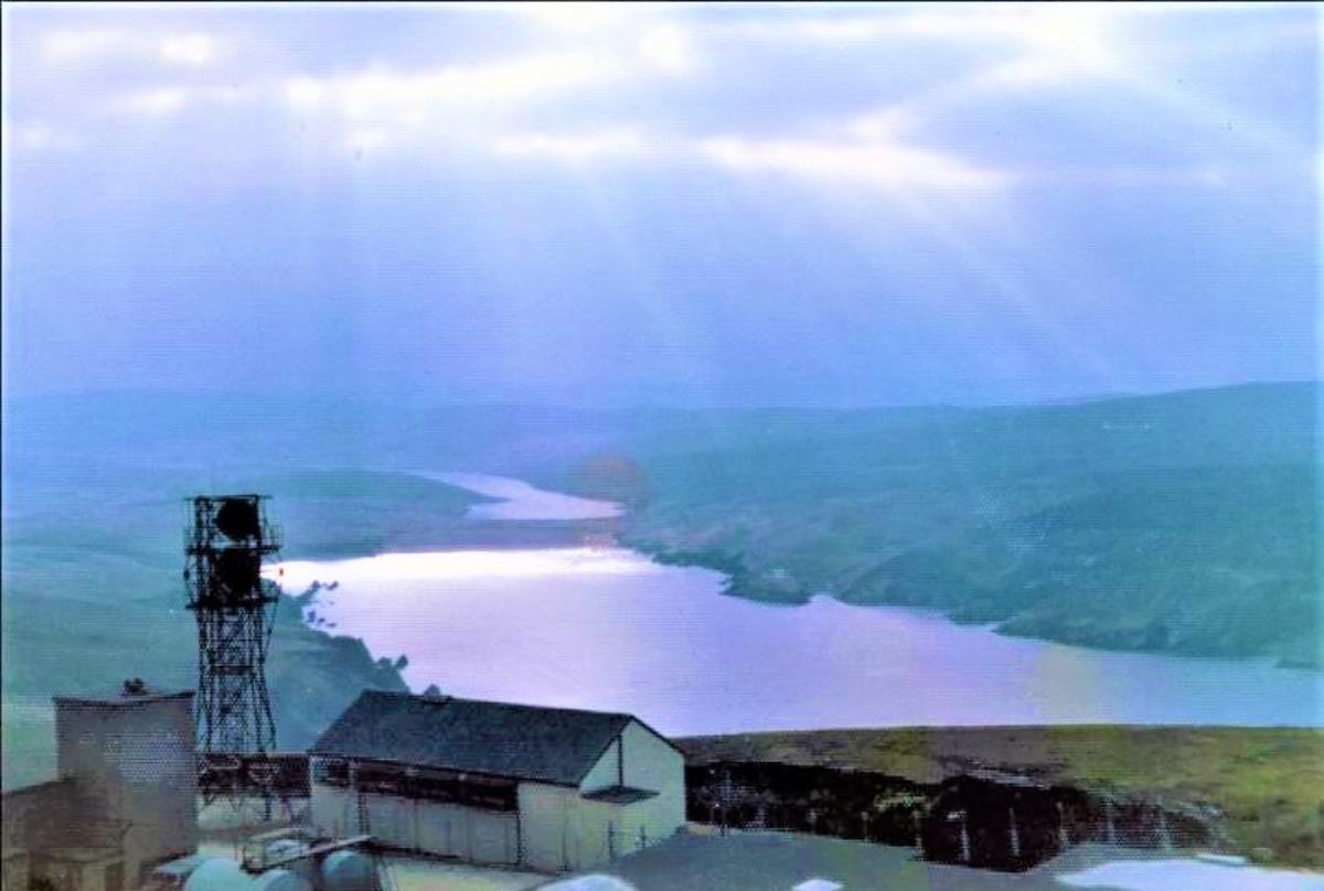
Norwick
- Shetlands Tail (Saxa Vord)
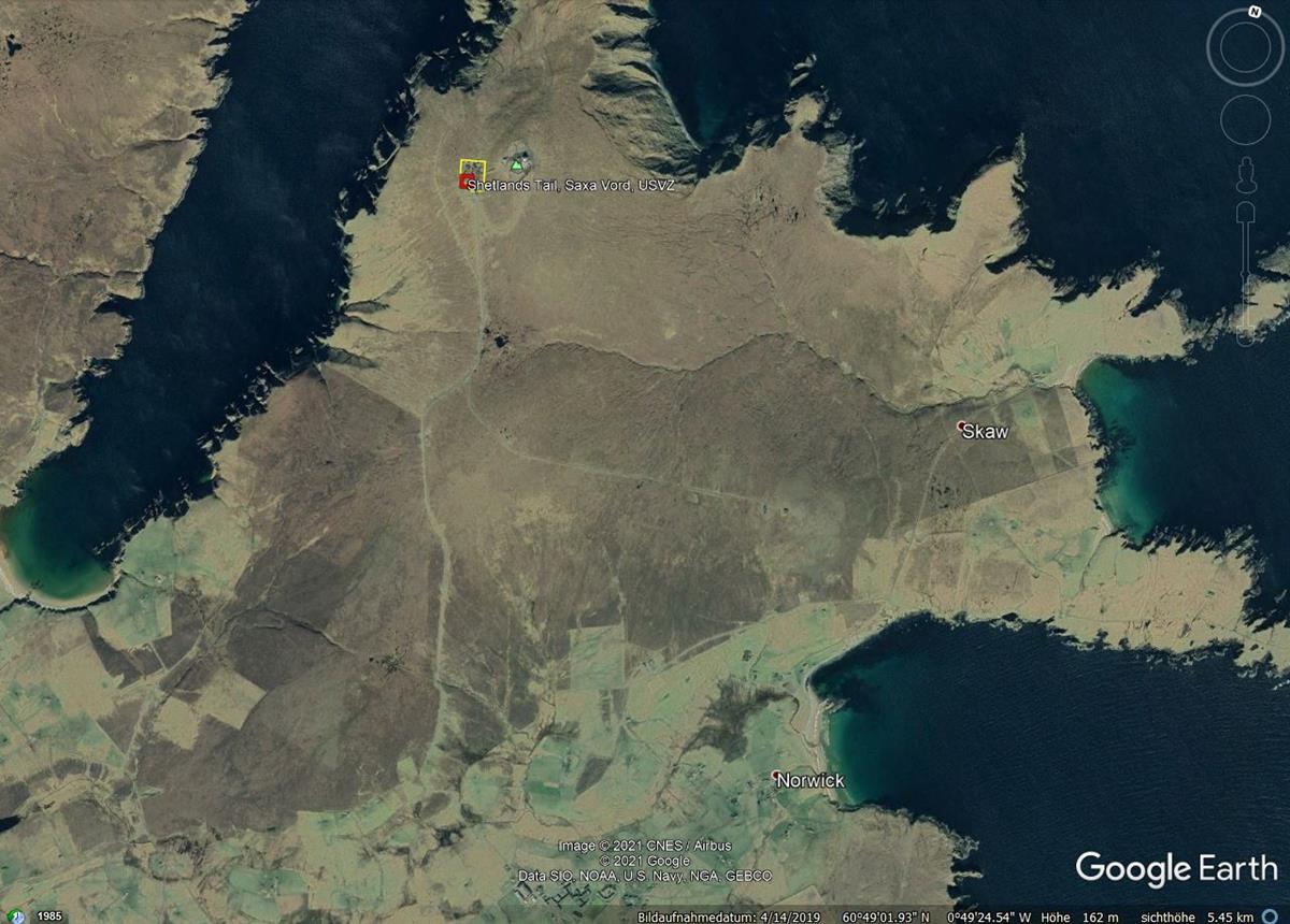
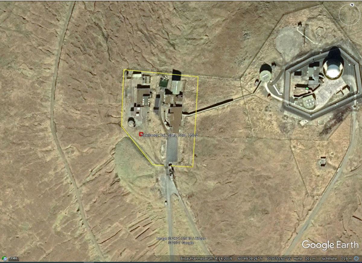
60°49'36.39"N/00°50'39.98"W - 229 m.üNN
Antennen üGND : L.o.S. Tower, Höhe unbekannt
Site Code ab 1958 : eac (Shetlands Tail)
Site Code ab 1971 : USVZ
Status : Aufgegebene Nutzung
Status heute : unbekannt
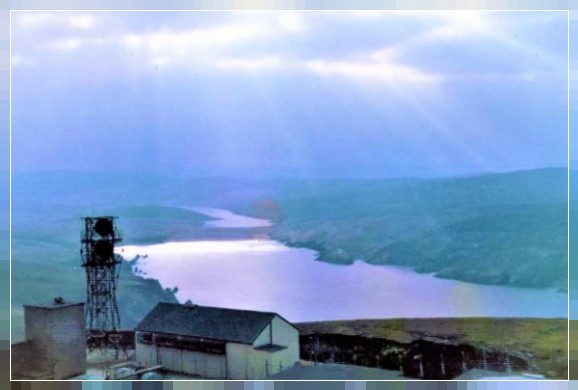
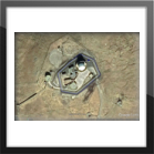
Ansicht : Liegenschaft [4]
___________________________________________________________________________________________________________________________________________________________________________________________________________
Übersichtspläne - Bezeichnungen - Transmitterverbindungen, 1959 (1) (3)

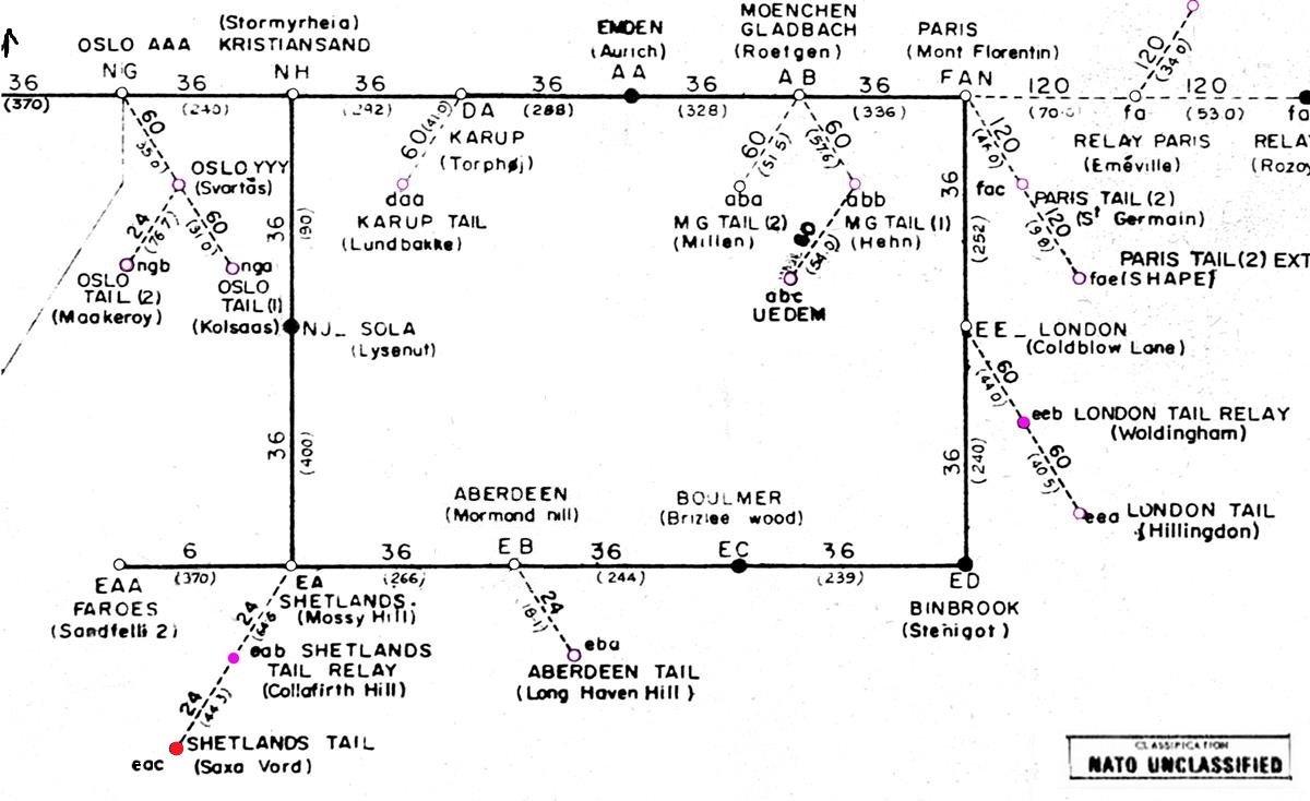
Verbindungen
eac - Shetlands Tail (Saxa Vord) > eab - Shetlands Tail Relay (Collafirth Hill) - L.o.S.-Line - Station mit Multiplex
Channel Capacity 24 - Entfernung zwischen den Stationen - Luftlinie - 44,50 Km
___________________________________________________________________________________________________________________________________________________________________________________________________________
Übersichtspläne - Bezeichnungen - Transmitterverbindungen, 1976 (1) (4)
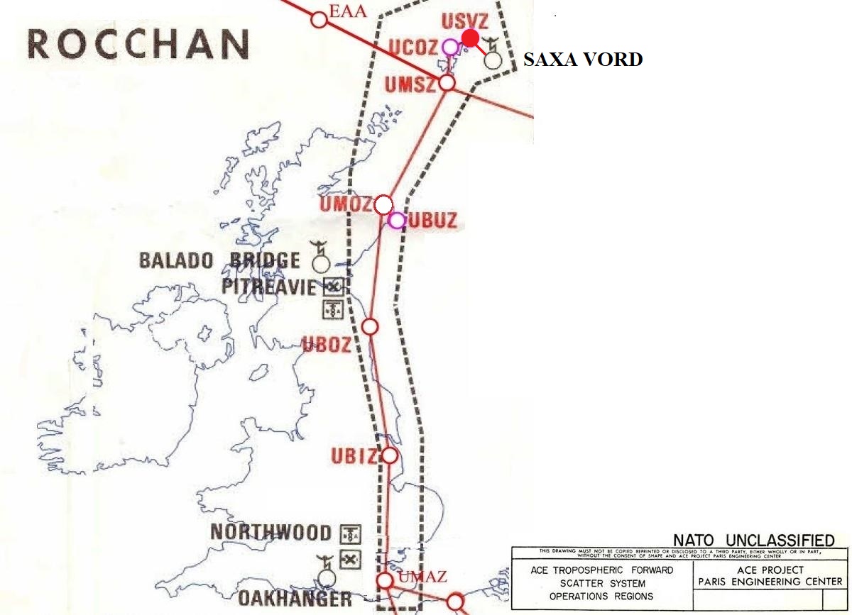
Verbindungen
USVZ - Shetlands Tail (Saxa Vord) > UCOZ - Shetlands Tail Relay (Collafirth Hill) - L.o.S.-Line - Station mit Multiplex
Channel Capacity 24 - Entfernung zwischen den Stationen - Luftlinie - 44,50 Km
______________________________________________________________________________________________________________________________________________________________________________
Linienplan, von 1976 (SatCom System)
Verbindungen
USVZ - Shetlands Tail (Saxa Vord) > SatCom Station F29 - Saxa Vord
Entfernung zwischen den Stationen - Luftlinie - 0,19 Km
___________________________________________________________________________________________________________________________________________________________________________________________________________
Power Category, Transmitter Typ
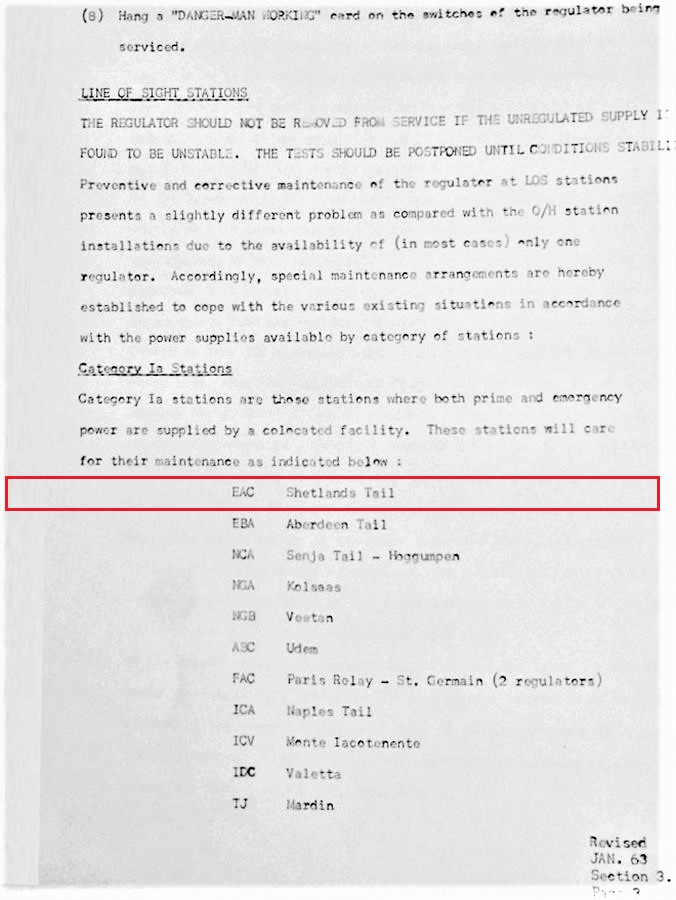
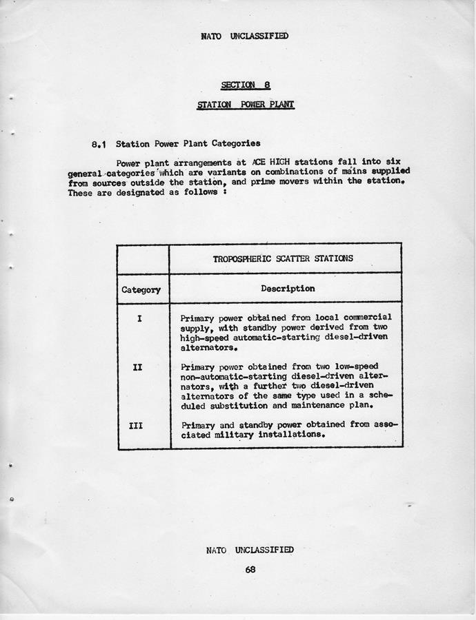
Station eac, Power Category - Ia
Station eac, Transmitter Typ - 1R (Radio Line)
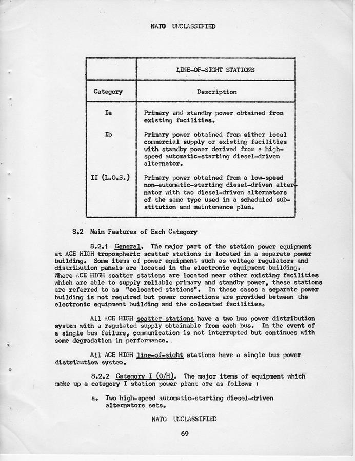
Info zu Station Power Plant Categories:
Power Plant arrangements at ACE High Stations fall into ix general categories with are variante on combinations of main supplied from sources the station, and prime movers within the station. There are designated as follows:
"Category Ia" Primary and standby power obtained from existing facilities.
___________________________________________________________________________________________________________________________________________________________________________________________________________
Beschreibungen
Link Seiten, Wikipedia
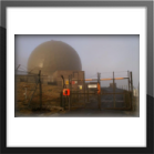
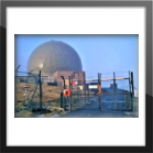
"Remote Radar Head Saxa Vord oder RRH Saxa Vord (auch bekannt als RAF Saxa Vord) ist eine Radarstation der Royal Air Force auf der Insel Unst, der nördlichsten der Shetlandinseln in Schottland. Seit Juli 2019 ist sie nach ihrer Schließung im Jahr 2 wieder eine voll funktionsfähige Radarstation[2006]. Das Motto des Senders Praemoneo de Periculis ("Vorahnung der Gefahr") spiegelt seine Rolle wider. Die RAF Saxa Vord liegt weiter nördlich als Sankt Petersburg in Russland und auf dem gleichen Breitengrad wie Anchorage, Alaska. Die Station wurde nach Saxa Vord benannt, der mit 935 ft (285 m) der höchste Hügel auf Unst ist. Er hält den inoffiziellen britischen Rekord für die Windgeschwindigkeit, der 1992 mit 197 mph (317 km/h) gemessen wurde – kurz bevor die Messgeräte weggeblasen wurden." [3]
_______________________________________________________________________________________________________________________________________________________________________________
Link Seiten, sonstige Publikationen
Thema, A History of RAF Saxa Vord
Autor - Gordon Carle [4]
Quelle - ACE High in Shetland [4]
ULR - Saxa Vord
Autor - Gordon Carle [4]
Quelle - ACE High in Shetland [4]
ULR - Saxa Vord
"ACE High in Shetland
ACE High was a NATO communications system which stretched over 8,000 miles from north Norway to eastern Turkey. Its purpose was to provide early warning links and to permit commanders to discuss strategy during the cold war period. Its’ origins were in the mid 50’s and it has now been superseded by other communications links. Over 80 ground stations were involved, half of which used large aerial arrays to propagate high frequency radio signals which were “bounced” over the horizon using tropospheric forward scatter techniques (hence FSS Mossy Hill – Forward Scatter Station). These Units also had microwave aerials which linked into the other sites, using line of sight techniques. The smaller stations were off-shoots from the main line of larger stations. I will leave the experts to explain the system in more detail. There is a good article on the Ace High System on the Subbrit site here:
So, back to the subject of this section, Ace High in Shetland. There were four main elements to the system in Shetland, Mossy Hill in the south mainland with its large tropospheric scatter arrays and microwave tower, 2 microwave “off-shoot” sites at Collafirth Hill and Saxa Vord and; fourthly, an admin and accommodation site at Maybury Camp at Virkie in the south mainland. (Left click on pictures to enlarge)." [4]
___________________________________________________________________________________________________________________________________________________________________________________________________________

Daten
Die ACE-High Station Shetlands Tail wurde in den Jahren "o.A" bis "o.A" erbaut und ging nach einer Testphase im Jahr "o.A" in die offizielle Betriebsphase. Die Bezeichnung der ACE-High Station lautete nach der offizielen Inbetriebnahme der Station "Shetlands Tail (Saxa Vord)" und die NATO Code hierzu war "eac".
eac - Shetlands Tail (Saxa Vord) (e) England (ac) NATO Codierung - Station ac
___________________________________________________________________________________________________________________________________
1971, wurden alle ACE-High Stationen im "ACE-High Network Europe" neu codiert, die Bezeichnung der ACE-High Station lautete danach "Shetlands Tail (Saxa Vord)" und die NATO Code hierzu war "USVZ".
1971, wurden alle ACE-High Stationen im "ACE-High Network Europe" neu codiert, die Bezeichnung der ACE-High Station lautete danach "Shetlands Tail (Saxa Vord)" und die NATO Code hierzu war "USVZ".
USVZ- Shetlands Tail (Saxa Vord) (U) United Kingdom of Great Britain (SV) Stadt / Geländebezeichnung (Z) ACE-High System
_______________________________________________________________________________________________________________________________________________________________________________
1991, Die Betriebsphase endete mit Schliessung der ACE-High Station im Januar.
______________________________________________________________________________________________________________________________________________________
Basis Personal der ACE-High Station
siehe Übersicht "Communications electronics personnel requirements for the ACE Frorward Scatter System"
___________________________________________________________________________________________________________________________________________________________________________________________________________
Hintergrundinformationen
"RAF Saxa Vord (RRH Saxa Vord, in Unst, with AN/TPS-77) is a remote radar station providing long-range radar coverage of its approaches. The data is fed into the Integrated Command and Control System within the UK"
_______________________________________________________________________________________________________________________________________________________________________________
NADGE Radar System
Die NADGE Radar Station Saxa Vord, NADGE Radar England (9), ist verbunden mit UK Air Surveillance and Control Systems, at RAF Boulmer und dem Control and Reporting Centre, at RAF Boulmer.
___________________________________________________________________________________________________________________________________________________________________________________________________________
heute (1)
Die militärische Nutzung der Liegenschaft durch das ACE-High System wurde vollständig beendet.
2019, Das Gelände der Liegenschaft, ist unter Google Earth erkennbar
___________________________________________________________________________________________________________________________________________________________________________________________________________
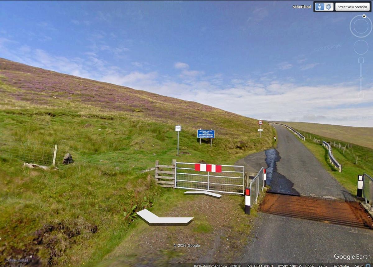
2010, Zufahrt zu der Liegenschaft.
______________________________________________________________________________________________________________________________________________________________________________________________________________
Bild - Quellenangaben
(PA) Privates Archiv
(1) Geographische Ansicht
(1) Google Earth, Google Street
(2) Wikipedia, Allied Forces Northwestern Europe
(3) Station Codes and Network Routes
(3) NATO Linienplan, 1959
(4) Geographic Locations of the NICS
(4) NATO Linienplan, 1976
(5) Wikipedia, Saxa Vord radome - geograph.org.uk - 311296.jpg / 2007
(6) Wikipedia, File:Saxa Vord radome - geograph.org.uk - 311296.jpg
Text - Quellenangaben[1] Wikimapia.org / Militär[1] Wikimapia[2] Wikipedia, Logo[3] Wikipedia, Saxa Vord[4] A History of RAF Saxa Vord[5] Handbuch, Volume I[5] Quellenschutz, ID 201_01[6] Power category Stations von 1963[6] Handbuch, Volume II, Section 3.1, Page 3[7] Wikipedia, NATO Integrated Air Defense System (NADGE)
"ace-high-journal.de" - alle Rechte bei WebMaster - Online seit 01.01.2009