England - ACE-High-Journal
Hauptmenü:
×
- Start Seite, WebSite
-
ACE-High System, Informationen
- ACE-High, WebSite Index
- Der Kalte Krieg
- ACE-High Network
- ACE-High Network France, die Geschichte
- ACE-High Station Feldberg, ein Zeitdokument
- ACE-High Station Feldberg, Karlsruhe 2.tes Meeting
-
NATO Kommunikation
- Cemetery Network
- Cronos
- DCS
- Double Jump
- Jocas
- NICS
- NTTS
- Last talk
-
Nationale Systeme
- BEMILCOM (Belgien)
- ASCON (Niederlande)
- NAFIN (Niederlande)
- DITSN (Italien)
-
NTTS (Italien)
- Info Seite, NTTS System
- FTASE, Alliierte Landstreitkräfte Südeuropas
- Nationaler Linienplan
- Affi, Bunker West Star, Site B
- Aviano, Air Base
- Brescia, Monte Maddalena, Site D
- Cansiglio, Site G
- Cavriana
- Collio, Dosso dei Galli
- Comano, Livorno
- Comerlati, Monte Comerlati, Site W
- Comiso, Air Base
- Concordia Sagittaria, Lame Concordia
- Crosara, Monte Alto, Site E
- Ghedi, Air Base
- Grezzana, Bunker Back Yard, Site A
- Lughenzzano, SatCom F14
- Milano
- Motta di Livenza
- Nisidia, Navy HQ NAVSOUTH
- Negrar, Monte Tondo
- Padua, Monte Venda
- Piacenza, Air Base
- Piancavallo, Site J
- Poggio Renatico
- Romano d`Ezzelino, La Gusella, Site F
- Site M (nicht aktiviert)
- Solbiate Olana
- Treviso-Istrana, Air Base
- Treviso-Sant Àngelo, Air Base
- Verona, Palazzo Carli
- Vicenza, Air Base, 5 ATAF
- Villafranca di Verona, Air Base
- Vittoria Veneto
- Volta Mantovana, Air Force, Site C
- PTT (Italien)
- 114F (Italien)
- 305 (Italien)
- Starrnet (U.K)
- NATO Verbandsabzeichen
- Linienführung
-
Technik
- Technik, Innenbereich
- Technik, Aussenbereich
- Technik, Komponenten
- Formblatt
- Handbücher
- No Break Unit
- Personal
- Warnungen
- Zeichnungen
- Impressum
-
Systeme vor dem ACE-High System
-
AIRCENT
- Info Seite, AIRCENT (1)
- Linienplan, AIRCENT
- Technik (Innen- und Aussenbereich)
- Fontainebleau (Camp AIRCENT HQ)
- A-1. Fontainebleau (Terminal-AIRCENT)
- A-2. Croix d'Augas
- A-3. Melun
- A-4. Jossigny
- A-4. Marly-le-Roi (Terminal-SHAPE)
- A-5. Éméville
- A-6. Margival (Crouy)
- A-6 / D-1. Margival (Laffaux)
- A-7 / D-2. St. Erme
- A-8 / D-3. Poix-Terron (La Bascule)
- B-3. Angevillers (Molvange, Bloc 7)
- Brassoir
- Brüssel-Evere, Terminal NATO HQ
- C-1. Lüttelforst
- C-2. Lammersdorf
- C-3. Roclenge-sur-Geer
- C-4. Baraque-de-Fraiture
- C-5. Vieux Moulins
- Chimay
- D-2. Jonchery-sur-Vesle
- D-4. Liart
- Haraumont
- Mönchengladbach (Terminal - 2. ATAF)
- Perl-Eft
- Plailly
- Trier-Euren (Mohrenkopf)
- Trier-Euren (Terminal Stab-4-ATAF)
-
Sonstige AIRCENT Stationen (2)
- Info Seite, AIRCENT (2)
- Bann
- La Fèrèe
- Mannheim-Seckenheim (Terminal)
- Marlemont
- Montlhèry
- Münchweiler
- Weiskirchen
-
LANDCENT
- Info Seite, LANDCENT (1)
- Linienplan, LANDCENT
- Technik (Innen-Aussenbereich)
- Bann (Kindsbach)
- Donnersberg
- Fontainebleau (Terminal B-La Madeleine)
- Mannheim-Seckenheim (Terminal B-CENTAG)
- Mönchengladbach (Terminal B-NORTHAG)
- Münchweiler
- R1. Dampleux
- R1 / R1. Marlemont
- R 2. La Haute-Maison
- R 2. Stonne
- R 3. Croix d'Augas
- R 3. Grandmenil
- R 3. Haraumont
- R 4. Angevillers (Bloc 7)
- R 4. Baraque Michel
- R 5. Perl-Eft
- R 6. Freisen
- Soissons (Terminal A)
- Weiskirchen
-
Sonstige LANDCENT Stationen (2)
- Info Seite, LANDCENT (2)
- Feschaux
- Fontainebleau (Camp Guynemer/LANDCENT HQ)
- Heidelberg HQ
- Le Mensil
- 2. Fontainebleau-Maintenace
-
AFCENT/JCA
- Info Seite, AFCENT/JCA (1)
- Linienplan, AFCENT/JCA
- Technik (Innen- Aussenbereich)
- 1- Fontainebleau, AFCENT HQ
- 2. Fontainebleau-Maintenance
- 3. Saint-Méry-Bombon
- 4. Bussières (La Haute-Maison)
- 4. La Haute-Maison
- 5. Dampleux
- 6. Lagery
- 7. St. Erme
- 8. Jossigny
- 9. Éméville
- 10. Margival (Laffaux)
- 11. Wahlhausen (ex 24)
- 12. La Bascule
- 13. Haraumont
- 14. Angevillers
- 15. Weiskirchen
- 16. Bann (Kindsbach)
- 17. Münchweiler
- 18. Marlemont
- 19. Vieux Moulins (AFCENT Site)
- 20. Baraque-de-Fraiture
- 21. Maastricht
- Maastricht-Kanne (Bunker Cannerberg)
- 21. Roclenge-sur-Geer
- 22. Lammersdorf
- 23. Mönchengladbach (Rheindahlen)
-
Sonstige AFCENT/JCA Stationen (2)
- Info Seite, AFCENT/JCA
- Prüm-Air Station (AS)
-
AFCENT/CRICS
- Info Seite, AFCENT/CRICS
- Linienplan, AFCENT/CRICS
- Baraque Michel
- Baraque-de-Fraiture
- Brunssum
- Erbeskopf
- Hornisgrinde
- Kindsbach
- Maastricht, "CENTAG"
-
Baraque Michel
- Maastrichr, "LCO"
- Pirmasens
- Prüm-Post
-
AIRCENT
-
Systeme mit dem ACE-High System
-
DEW System
- Info Seite, DEW
- Linienplan, DEW
- DYE-5, Keflavik
- DYE-4, Kulusuk
-
NARS System
- Info Seite, NARS
- Linienplan, NARS
- Faröer, Site 43
- Flyingdales, Site 46
- Höfn, Site 42
- Keflavik, Site 41
- Mormond Hill, Site 44
-
DEW System
-
ACE-High System
- Info Seite, ACE-High System
-
Bereich, ACCHAN
-
England
- Info Seite, ACCHAN
- Linienplan, ACCHAN
- Aberdeen
- Aberdeen Tail
- Binbrook
- Boulmer
- Faroes
- London
- London Tail
- London Tail Relay
- Shetlands
- Shetlands Tail
- Shetlands Tail Relay
-
England
-
Bereich, AFNORTH
-
Dänemark
- Info Seite, AFNORTH
- Linienplan, AFNORTH
- Kollemorten
- Lundebakke
-
Norwegen
- Info Seite, AFNORTH
- Linienplan, AFNORTH
- Konferenz, AFNORTH
- Bodø
- Bodø Tail
- Kolsås
- Høggumpen
- Kristiansand
- Lysenut
- Mågerø
- Mosjøen
- Oslo
- Senja
- Svartås
- Trondheim
- Trondheim Tail
-
Dänemark
-
Bereich, AFCENT
-
Belgien
- Info Seite, AFCENT
- Linienplan, AFCENT
- Adinkerke
- Baraque-de-Fraiture
- Casteau (SHAPE)
- Chievres
-
Deutschland
- Info Seite, AFCENT
- Linienplan, AFCENT
- Aurich
- Feldberg
- Hehn
- Kindsbach
- Lammersdorf
- Moenchen-Gladbach, Teil (2) (Millen)
- Uedem
-
Frankreich
- Info Seite, AFCENT
- Linienplan, AFCENT
- Éméville
- Lyon
- Nice
- Paris North
- Paris South
- Paris Tail (1), Laffaux
- Paris Tail (2), Extension-SHAPE
- Paris Tail (2), St. Germain
- Paris, Tour Eiffel control center
- Rohrbach
- Rozoy-Bellevalle
- Taverny
-
Niederlande
- Info Seite, AFCENT
- Linienplan, AFCENT
- Brunssum
- Maastricht
-
Belgien
-
Bereich, AFSOUTH
-
Griechenland
- Info Seite, AFSOUTH
- Linienplan, AFSOUTH
- Athens
- Athens Tail
- Ismaros
- Kefallonia
- Larissa
- Larissa Tail
- Vitsi
- Ziros
-
Italien
- Info Seite, AFSOUTH
- Linienplan, AFSOUTH
- Aviano Lame Tail
- Catanzaro
- Cavriana
-
Dosso dei Galli
- Dosso dei Galli (1)
- Dosso dei Galli (2)
- Beschreibung (Deutsche-Version)
- Beschreibung (Versione-italiana)
- Bilddokumentationen 1969>1974
- Bilddokumentationen 1975>2004
- Bilddokumentationen 2005>2009
- 2009, Anniversary 40 Jahre
- Bilddokumantationen 2010>2019
- 2019, Anniversary 50 Jahre
- Bilddokumentationen 2020>heute
- Publikationen
- Lame Concordia
- Latina School
- Livorno
- Malta (Gharghur)
- Malta (Floriana)
- Martina Franca
- Monte Iacotenente
- Monte Lauro
- Monte Petrino
- Monte Vergine
- Monte Vulture
- Naples
- Pietra Ficcata
- Rome
- Rome Tail
- Verona Tail
- Verona Torre 4
-
Türkei
- Info Seite, AFSOUTH
- Linienplan, AFSOUTH
- Adana
- Adana Tail
- Amasra
- Ankara
- Ankara Tail
- Cyprus
- Diyarbakir
- Diyarbakir Tail (Air Base)
- Eskisehir
- Eskisehir Tail
- Izmir
- Izmir Tail
- Mardin
- Merzifon
- Pazar
- Persembe
- Sivas
-
Griechenland
-
Sonstige Objekte
-
Gedenkstätten, Museen
-
Belgien
- Info Seite, Gedenkstätten, Museen
- Adinkerke, Kriegsgräber
- Adinkerke, Museum Cabour WK II
- Elsenborn, Truschbaum Museum
- Grandemènil, Denkmal
- Grandemènil, Panther G
- Joubiéval, Museum
- Kanne, Flieger Denkmal
- Kanne, Kriegsgräber
- Kanne, Denkmal 1940
- Leoboldsburg, Kriegsgräber
- Poteau, 44 Museum
-
Deutschland
- Info Seite, Gedenkstätten, Museen
- Hehn-Heiligenpesch, Wallfahrtort
- Heimbach, Ehrenfriedhof Mariawald
- Hürtgen, Kriegsgräber
- Marienborn-Helmstedt, Gedenkstätte
- MG-Rheindahlen, Military Cemetery
- Peenemünde, Museum
- Pütnitz, Technik Museum
- Sinsheim, Technik Museum
- Viersen-Süchteln, Kriegerdenkmal
- Vossenack, Kriegsgräber
- Waldniel, Gedenkstätte I
- Waldniel, Gedenkstätte II
-
Frankreich
- Info Seite, Gedenkstätten, Museen
- Belleau, Le Bois Belleau, Kriegsgräberstätte
- Belleau, Kriegsgräberstätte
- Château-Thierry, Cote 204
- Compiègne, Gedenkstätte
- Douaumont, Gedenkstätte
- Mondement-Montgivroux, Memorial
- Montmirail, Monument Napoleon
- Soizy aux Bois, Kriegsgräberstätte
- Valmy-Quartier Douenc, Historische Stätte
- Vauxbuin, Kriegsgräberstätte
- Verdun, Memorial de Verdun
- Verdun-Bevaux, Kriegsgräberstätte
-
Belgien
-
Militärische Objekte
-
Belgien
- Air Base, Flughafen
-
Munitionslager, Sonderwaffenlager
- Info Seite, Munitionslager
- Houthulst
-
Richtfunk
- Info Seite, Richtfunk
- Info Seite, BeMilCom
- Adinkerke, Site 080
- Arlon, Site Kaserne Callemeyn
- Battice, Site 024
- Ben-Ahin, Site Mx
- Brüssel-Evere, Terminal NATO HQ
- Court-Saint-Etienne
- Court-Saint-Etienne, Site Mx
- D`Hoppe, Site Mx
- Elsenborn, Site Camp Elsenborn
- Eupen
- Everberg, Site 115
- Genk
- Hannut, Site 055
- Houthulst
- Kester-Heide, Site Mx
- Kester-Heide, Site 251
- Latin, Site Mx
- Millen, Site Mx
- Millen, Site 056
- Molenbeek, Site Mx
-
TrÜbPl, Kasernen
- Info Seite, TrÜbPl, Kasernen
- Elsenborn, Camp Elsenborn
- Leopoldsburg, Camp Beverlo
-
WK I, Objekte
- Info Seite, WK I, Festungen
- Lüttich, Fort Barchon
- Lüttich, Fort Boncelles
- Lüttich, Fort Chaudfontaine
- Lüttich, Fort Embourg
- Lüttich, Fort Evegnèe
- Lüttich, Fort Flémalle
- Lüttich, Fort Flèron
- Lüttich, Fort Hollogne
- Lüttich, Fort Lantin
- Lüttich, Fort Liers
- Lüttich, Fort Loncin
- Lüttich, Fort Pontisse
-
WK II, Objekte
- Info Seite, WK II, Festungen
- Lüttich, Fort Aubin-Neufchâteau
- Lüttich, Fort Battice
- Lüttich, Fort Eben-Emael
- Lüttich, Fort Tancremont
- Vroenhoven, Brücken-Denkmal
-
Dänemark
-
TrÜbPI
- Info Seite, TrÜbPI
- Finderup, TrÜbPI Finderup
-
TrÜbPI
-
Deutschland
-
Air Base, Flughafen
- Info Seite, Air Base, Flughafen
- Baden-Söllingen, Air Base
- Geilenkirchen, Air Base
- Laarbruch, Air Base
- Lahr, Air Base
- Nörvenich, Air Base
-
FlaRak
-
FlakRak, Hawk
- Info Seite, Hawk
- Deutschland
- FlaRak, Nike-Herkules
- FlaRak, Pershing
-
FlakRak, Hawk
-
GSVBw
- Info Seite, GSVBw
- Sankt Martin, Bunker "GSVBw44"
-
Kasernen
- Info Seite, Kasernen
- Altenwalde, Hinrich-Wilhelm-Kopf-Kaserne
- Bad Bergzabern, Mackensen Kaserne
- Borgenstreich, Desenberg Kaserne
- Clausthal-Zellerfeld, Oberharz-Kaserne
- Düren, Belgische Panzer Kaserne
- Erndtebrück, Hachenberg Kaserne
- Euskirchen, Mercator Kaserne
- Freising, General-von-Stein-Kaserne
- Freising, Vimy-Kaserne
- Karlsruhe, General-Fahnert-Kaserne
- Köln, Luftwaffenkaserne
- Lauda, Tauberfranken Kaserne
- Meßstetten, Zollernalb-Kaserne
- Mönchengladbach, Niederrhein Kaserne
- Oldenburg, Donnerschwee Kaserne
- Rendsburg, Eider-Kaserne
- Seebach, Hornisgrinde Kaserne
- Trier-Euren, General-von-Seidel-Kaserne
- Ulm, Wilhemsburg Kaserne
- Varel, Friesland Kaserne
-
Munitionslager, Sonderwaffenlager
- Info Seite, Munitionslager
- Fischbach, Area One
- Geilenkirchen, Atomwaffenlager
- Geilenkirchen, Munitionslager
- Gemünd, Munitionslager
-
NVA, Objekte
- Info Seite, NVA Objekte
- Binz, Prora
- Börgerende, Grenzturm
- Kühlungsborn, Grenzturm
- Lindholz, Bunker 302 (Eichenthal)
- Prerow, alte Liegenschaft
- Prerow, Darßer Ort, Stellung
- Prerow, Darßer Ort, Fernmelde Verteiler
- Zingst, Truppenübungsplatz
- Zingst, Wasserbunker
-
Polygone, Objekte
- Info Seite, Polygone Objekte
- Bann, Site Alpha
- Bann, Site Bravo
- Breitenbach
- Pirmasens-Husterhöhe
- Salzwoog
- Zweibrücken-Oberauerbach
-
Richtfunk
- Info Seite, Richtfunk
- Altenwalde
- Bad Bergzabern, Sauhäusel
- Bitburg, Air Base
- Eschers-Untrasried
- Feldberg (Schwarzwald)
- Freudenstadt, Alexanderschanze
- Geilenkirchen, Air Base
- Lahr, Air Base
- Leimen-Christelseck
- Maikammer, Kalmit
- Prerow, Darßer Ort
- Rettersen
- Schöneberg
- Schwagsdorf
- Seebach (Hornisgrinde)
- Spangdahlem, Air Base
-
TrÜbPl
- Info Seite, TrÜbPI
- Baumholder, TrÜbPI Baumholder
- Eckersweiler, Aussenfeuerstelle Nr 205
- Gemünd, Camp Vogelsang
- Gemünd, TrÜbPl Vogelsang
- Gemünd, TrÜbPl Vogelsang Dorf Wollseifen
- Gemünd, "Igel Stellung"
- Hitfeld, Camp Hitfeld
- Meßstetten, TrÜbPl Heuberg
-
U.S. Objekte
- Info Seite U.S. Objekte
- Bann, Site Alpha
- Bann, Site Charly
- Bitburg, Air Base
- Darmstadt, Army Air Field
- Friolzheim, Radio Relay Site 12
- Geigenwang, Radio Relay Site 16A "Chrysler"
- Heidelberg, Campbell Barracks
- Hofstätten, Radio Relay Site 101 "Langerkopf"
- Mannheim, Hammonds Barracks
- Maßweiler, Bunker Cave 7921
- Pirmasens, Army Depot Site 17
- Pirmasens, Husterhoeh Kaserne
- Sembach, Air Base
- Spangdahlem, Air Base
- Ramstein, Air Base
- Stocksberg
- Stuttgart-Burgholzhof, Robinson Barracks
- Stuttgart-Vaihingen, Patch Barracks
-
WK II, Objekte
- Info Seite, WK II, Objekte
- Aurich, Flakstellung
- Paustenbach, Eifelkreuz
-
WK II, Westwall
- Westwall, Übersicht Festungsabschnitte
-
Aachen-Saar Programm
- Westwall, Übersicht, Aachen-Saar
- Bad Bergzabern, Westwall Museum
- Simonskall, Sanitätsbunker
- Schmithof, Höckerlinie
- Lammersdorf, Höckerlinie
- Langschoß, Wasserbunker
- Vossenack, Hürtgenwald Museum
-
Ettlinger Riegel
- Westwall, Übersicht, Ettlinger Riegel
- in Vorbereitung
-
Geldernstellung
- Westwall, Übersicht, Geldernstellung
- in Vorbereitung
-
Isteiner Klotz
- Westwall, Übersicht, Isteiner Klotz
- in Vorbereitung
-
LVZ-West
- Westwall, Übersicht, LVZ-West
- Bad Münstereifel, FHQ "Felsennest"
- Kniebis, FHQ "Tannenberg"
- Seebach (Hornisgrinde), LVZ-West Stellung
- Seebach (Schliffkopf), LVZ-West Stellung
-
Orscholzriegel
- Westwall, Übersicht, Orschozriegel
- Pirmasens-Niedersimten, Museum Gerstfeldhöhe
-
Air Base, Flughafen
-
Frankreich
-
Polygone, Objekte
- Info Seite, Polygone Objekte
- Chenevières, Site 03
- Èpinal, Site 01
- Grostenquin, Site 02
-
TrÜbPI, Kasernen
- Info Seite, TrÜbPI, Kasernen
- Angevillers, Camp d`Angevillers
- Margival, Camp de Margival, AFCENT WHQ
-
WK I, Objekte
- Info Seite , WK I, Objekte
- Contè-sur-Aisne, Fort Contè
- Duzey, Canon Allemand
- Verdun, Fort de Douaumont
- Verdun, Fort de Souville
- Verdun, Fort de Vaux
-
WK II, Objekte
- Info Seite, WK II, Objekte
- Rochonvillers, Anlage "Brunhilde"
-
WK II, Maginot Line
- Übersichtsplan, Maginot
-
8 Secteur Fortifiè de la Crusnes
- Übersicht, 8 S.F.
- Info Seite, 8 S.F.
- Gros Ouvrage Fermont
-
9 Secteur Fortifiè de Thionville
- Übersicht, 9 S.F.
- Info Seite, 9 S.F.
- Abri du Grand Lot
- Camp d`Angevillers
- Casemate d`Escherange Ouest
- Casemate du Grand Lot
- Abri de tir (du petit Lot, 1)
- Abri de tir (du petit Lot, 2)
- Gros Ouvrage Rochonvillers Bloc 1 > 8
- Gros Ouvrage Rochonvillers Bloc 9
-
10 Secteur Fortifiè de Boulay
- Übersicht, 10 S.F.
- Info Seite, 10 S.F.
- Gros Ouvrage Hackenberg
- Gros Ouvrage Michelsberg
- Abri de Bilmette
- Blockhaus Bb 9
- Gros Ouvrage Mont des Welches
- Abri de Mont des Welches
- Abri d`Ising
-
12 Secteur Fortifiè de la Sarre
- Übersicht, 12 S.F.
- Info Seite, 12 S.F.
- Petit Ouvrage Haute-Poirier
- von Bettviller nach Achen
-
13 Secteur Fortifiè de Rohrbach
- Übersicht, 13 S.F.
- Info Seite, 13 S.F.
- Gros Ouvrage Simserhof
- Casemate du Lègeret
- Casemate Bining
- Abri de tir, Biningerwiese
- Petit Ouvrage Rohrbach (Fort Casso)
- Petit Ouvrage Welschhof
-
14 Secteur Fortifiè des Vosges
- Übersicht, 14 S.F.
- Info Seite, 14 S.F.
- Gros Ouvrage du Four-à-Chaux
-
15 Secteur Fortifiè de Haguenau
- Übersicht, 15 S.F.
- Info Seite, 15 S.F.
- Abri de tir de Birlenbach
- Casemate de Bremmelbach Nord
- Casernement de Drachenbronn
- Gros Ouvrage de Hochwald Est
- Gros Ouvrage de Hochwald Ouest
- Abri de Hatten
- Abri de tir Hatten
- Casemate d`Ingolsheim Est
- Casemate d`Ingolsheim Ouest
- Casemate Esch
- Casemate la Selz
- Observatoire de Hatten
- Gros Ouvrage Schoenenbourg
- Abri de tir Pfaffenschlick Sud
- Casemate du Bois de Rittershoffen 1
- Casemate du Bois de Rittershoffen 2
- Casemate du Bois de Rittershoffen 6
-
Polygone, Objekte
-
Italien
-
Grande Guerra, Objekte
- Info Seite, Grande Guerra
- Anfo, Forte Clima Ora
- Lubiara, Forte San Marco
- Maniva, Caserma Casaliti (Locanda Bonardi)
- Maniva, Caserma Casermone
- Maniva, Caserma Giogo Bala
- Maniva, Giogo del Maniva
- Pastrengo, Forte Bendeck
- Pastrengo, Forte Degenfeld
- Pastrengo, Forte Nugent
- Pastrengo, Forte Leopold
- Pastrengo, Telegrafo Ottico
- Rivoli Veronese, Forte d`Tagliata d' Incanal
-
Munitionslager, Sonderwaffenlager
- Info Seite, Munitionslager
- Ghedi, Atomwaffenlager
-
TrÜbPI, Kasernen
- Info Seite, TrÜbPI, Kasernen
- Verona, Caserma Busignani
- Verona, Caserma Li Gobbi
-
Grande Guerra, Objekte
-
Niederlande
-
TrÜbPl, Kasernen
- Info Seite, TrÜbPl, Kasernen
- Maastricht, Tabijn Kaserne
-
TrÜbPl, Kasernen
-
Österreich
-
WK I, Objekte
- Info Seite, WK I, Objekte
- Festung Nauders
-
WK I, Objekte
-
Schweiz
-
WK II, Objekte
- Info Seite, WK II, Objekte
- Airolo, Artilleriewerk Airolo
- Airolo, Artilleriewerk Foppa Grande
- Airolo, Artilleriewerk San Carlo
- Airolo, Artilleriewerk Sasso da Pigna
- Airolo, Hospizwerk Gottardo
-
WK II, Objekte
-
Belgien
-
Zivile Objekte
-
Deutschland
- Info Seite, Zivile Objekte
- Bad Münstereifel, Effelsberg, Radioleleskop
- Bad Münstereifel, Stockert, Astropeiler
- Calmbach, Klinik Chalottenhöhe
- Dannenfels, Ludwigturm
- Feldberg, Schwarzwald
- Feldberg, Taunus
- Kniebis, Hotel Alexanderschanze
- Langschoß, Feuerwachtturm
- Maikammer, Kalmit
- Mönchengladbach, Verkehrslandeplatz
- Mülheim, Verkehrslandeplatz
- Schwalmtal, Fabrikanlage
- Viersen-Süchteln, Irmgardiskapelle
- Viersen-Süchteln, Historischer Wasserspeicher
- Weeze, Schloss Wissen
-
Deutschland
-
Zivile Bunker
-
Dänemark
- Info Seite, Zivile Bunker
- Regan Vest
-
Deutschland
- Info Seite, Zivile Bunker
- Meerbusch, Hochbunker "Böhler"
- Mönchengladbach, Lürriper Strasse
- Satzvey, Sonderbauwerk "Steinfurt"
- Staffel, Postbunker "Sonderbetriebsstelle Kesseling 0"
-
Dänemark
-
Ziviler Richtfunk
-
Belgien
- Info Seite, Richtfunk
- Elst
- Frameries
- Hannut, Site RTB
- Oostvleteren
- Ypern
-
Deutschland
- Info Seite, Richtfunk
- Liste der Typentürme
- Baden-Baden, Merkurturm
- Bambergerhof, BNetzA Peiler
- Bielefeld (Hünenburg)
- Bremen-Walle, FMT
- Bremen-Woltmershausen
- Brocken
- Clenze (Clenze 1)
- Dieblich-Naßheck, Sender Koblenz
- Düsseldorf, Rheinturm
- Feldberg (Schwarzwald), SWR Sender
- Gernsbach, Hohloh
- Gollenberg
- Grevenbroich, Vollrather Höhe
- Großhau, FMT
- Holzminden, Köterberg
- Gartow (Höbeck)
- Kniebis
- Lauschied
- Lübbecke
- Mönchengladbach, FMT
- Nettetal-Hinsbeck
- Nottuln, WDR Sender
- Ober-Abtsteinach, HR Sender
- Reichweiler, FMT
- Schömberg, Sender Langenbrand
- Schöneberg, FMT
- Seebach (Hornisgrinde), SWR Sender
- Seebach (Hornisgrinde), Transmitter (Mobilfunk)
- Seebach (Hornisgrinde), Telekom
- Sulzbach-Rosenberg
- Sulzbach-Rosenberg, Transmitter (Mobilfunk)
- Torfhaus
- Viersen-Bockert
- Viersen-Süchteln, FMT
- Waldböckelheim
- Wallhausen, Transmitter (Mobilfunk)
- Wehrheim, Roßkopf
- Wildeshausen
- Willich-Schiefbahn, FMT
- Würselen, Transmitter (Mobilfunk)
-
Deutschland (Berlin)
- Info Seite, Richtfunk Berlin
- Berlin-Britz
- Berlin-Frohnau
- Berlin-Köpenick, Müggelberge
- Berlin-Köpenick, Sender Berlin-Köpenick
- Berlin-Mitte, Fernsehturm
- Berlin-Nikolasee
- Berlin-Schöneberg
- Berlin-Wannsee, Erdfunkstelle
- Berlin-Wannsee, Schäferberg (Berlin 3)
- Berlin-Westend, Funkturm
- Berlin-Westend, Scholzplatz
- Berlin-Westend, Stallupöner Allee
- Berlin-Zehlendorf
-
Frankreich
- Info Seite, Richtfunk
- Le Bois de Molle
- Wissembourg, Eselberg
- Wissembourg, Klingfeld
-
Schweiz
- Info Seite, Richtfunk
- Arth-Goldau, Rigi Kulm
-
Belgien
-
Gedenkstätten, Museen
-
Sonstige Systeme
-
BARS "БАРС" Schneeleopard
- Info Seite, BARS
- Übersichtsplan, BARS
- Lindholz, Bunker 302 (Eichenthal)
-
BAOR/RAF Germany
- Info Seite, BAOR/RAF
- Übersichtsplan, BAOR/RAF
- Arsbeck
- Bielefeld (Ebberg)
- Bielefeld (Hünenburg)
- Birgelen
- Brüggen
- Deister (Annaturm)
- Dörenberg (BFBS)
- Groß Gusborn (BFBS)
- Hehn
- Hostert, Britisch Military Hospital
- Krefeld
- Lübbecke ridge BFBS Transmitter (Holsen)
- Mönchengladbach
- Roetgen (Lammersdorf)
- Schwalmtal, HQ NAAFI Waldniel
- St.Tönis, Francisca Barracks
- Weeze-Laarbruch, RAF Air Base
- Wegberg, RAF Hospital
- Wildenrath, RAF Air Base
- Willich, Kitchener Barracks
-
Echolon Netzwerk
- Info Seite, Echolon
- Ayios Nikolaos Station, Cyprus
- Bad Aibling
- Berlin, Teufelsberg
-
ET-A System
- Info Seite, ET-A
- Linienplan, ET-A
-
Belgien
- Info Seite, Belgien
- Ben-Ahin
- Casteau
- Chièvres
- Flobecq
- Houtem
- Le Chenoy
- Spa-Malchamps
- Westrozebeke
-
Deutschland
- Info Seite, Deutschland
- Adenau (Raßberg)
- Berlin, Dahlem
- Berlin, Marienfelde
- Berlin, Olympiastation
- Berlin, Schäferberg
- Berlin, Tempelhof
- Berlin, Teufelsberg
- Bocksberg
- Breitsol
- Bremerhaven (Carl-Schurz Kaserne)
- Donnersberg
- Feldberg (Schwarzwald)
- Feldberg (Taunus)
- Heidelberg
- Hohenpeissenberg
- Hohenstadt
- Holzminden, Köterberg
- Linderhofe
- Munich
- Nuernberg
- Schönfeld (Prüm Air)
- Stein
- Wunstorf, Air Base
- Zugspitze
-
England
- Info Seite, England
- Martlesham Heath
- RAF Fylingdales
-
Frankreich
- Info Seite, Frankreich
- Camp Bussac
- Dreux-Louvilliers, Air Base
- Maison Fort
- Nancy, Emergency Airfield
- Paris (Camp des Loges)
- Vatry, Air Base
-
Niederlande
- Info Seite, Niederlande
- Hoeck van Holland
-
RAF UK > BAOR, Scatterlink
- Info Seite, Scatterlink
- Linienplan, Scatterlink
- Roetgen (Deutschland)
- Swingate (England)
-
Royal Air Force, UK
- Info Seite, RAF UK
- Linienplan, RAF UK
- Bulbarrow Hill
- Dean Hill
- Fylindales Moor
- Golden Pot Towers
- High Wycombe Air Base
- HQ Northwood
-
Royal Air Force, Cyprus
- Info Seite, RAF Cyprus
- Linienplan, RAF Cyprus
- Akrotiri
- Akrotiri, Dekalia
- Ayios Nikolaos Station
- Cyta Yeroskipos
- Lincolnshire Poacher
- Troodos
-
Medcom System, 486L
- Info Seite, 486L Medcom
- Linienplan, 486L Medcom
-
England
- Info Seite, England
- Ringstead Bay
-
Griechenland
- Info Seite, Griechenland
- Levkas, Site 14B
- Mount Edheri, Site 24D
- Mount Pateras, Site 15H
-
Italien
- Info Seite, Italien
- Cima Gallina, Site 120
- Cima Grappa
- Cima Paganella
- Coltano, Site 9L
- Martina Franca, Site 7A
- Monte Cimone
- Monte Corna
- Monte Limbara, Site 4C
- Monte Nardello, Site 6E
-
Monte Vergine, Site 5F
- Monte Vergine, Site 5F
- Padua, Monte Venda
- Savona, Site 56
- Sigonella
-
Spanien
- Info Seite, Spanien
- Gorramendi, Site 163
- Guardamar, Site 33
- Humosa, Site 1A
- Inogès, Site 21
- Menorca, Site 3B
- San Pablo, Site 108
- Mallorca, Site 3H
-
Türkei
- Info Seite, Türkei
- Adana, Site 129
- Balikesir, Site 32
- Elmadağ, Site 142
- Malatya, Site 105
- Şahin Tepesi, Site 30G
- Samsun, Site 137
- Sinop, Site 121
- Yamanlar, Site 16D
-
BARS "БАРС" Schneeleopard
- Info Seite, NADGE
- Übersichtsplan, NADGE
- Technik, NADGE
- Belgien, (1) > (~)
- Dänemark, (1) > (~)
- Deutschland, (1) > (15)
- Deutschland, (16) > (30)
- Deutschland, (31) > (~)
- England, (1) > (~)
- Frankreich, (1) > (~)
- Griechenland, (1) > (15)
- Griechenland, (16) > (~)
- Italien, (1) > (15)
- Italien, (16) > (~)
- Niederlande, (1) > (~)
- Norwegen, (1) > (15)
- Norwegen, (16) > (~)
- Spanien, (1) > (15)
- Spanien, (16) > (~)
- Türkei, (1) > (15)
- Türkei, (16) > [~)
Sonstige Objekte > Militärische Objekte > Deutschland > NADGE System
Flugabwehr
(NADGE-NATO Air Defence Ground Environment)
Technische Komponenten, England
AN/FPS-117
AN/TPS-77
AR-327
Technische Komponenten, England
AN/FPS-117
AN/TPS-77
AR-327
_______________________________________________________________________________________________________________________________________________________________________________________________________________
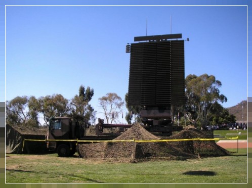
(3) Wikipedia, File:RAAF AN-FPS-117 radar in 2007.jpg
__________________________________________________________________________________________________________________________________________________________________________________________________________________________________________________________________________________
Beschreibungen
Link Seiten, Wikipedia

"Das AN/FPS-117 ist ein 3-dimensionales Luftsuchradar mit aktiver elektronischer Abtastung (AESA) im L-Band, das erstmals 1980 von GE Aerospace hergestellt wurde und heute Teil von Lockheed Martin ist. [1][2] Das System bietet instrumentierte Detektion in Entfernungen in der Größenordnung von 200 bis 250 Seemeilen (370 bis 460 km; 230 bis 290 Meilen) und verfügt über eine Vielzahl von Interferenz- und Störunterdrückungssystemen.
Das System wurde ursprünglich als Teil der "Seek Igloo/Seek Frost"-Bemühungen entwickelt, um die älteren Radarsysteme der DEW-Linie durch Konstruktionen zu ersetzen, die ferngesteuert betrieben werden können und viel weniger Wartung erfordern, als Teil des DEW-Ersatzes, des American-Canadian North Warning System (NWS). Die Implementierung des NWS führte zu einer Reduzierung der Betriebs- und Wartungskosten um bis zu 50 % im Vergleich zu früheren Systemen.
GE nahm eine Reihe von Änderungen am Grunddesign vor, um es besser auf verschiedene Rollen zuzuschneiden. Um einen Bedarf für das US Marine Corps zu decken, entwickelte GE die transportable AN/TPS-59 und kombinierte später Konstruktionselemente, um die kleinere AN/TPS-77 zu produzieren, die noch mobiler ist und in einigen Einsatzszenarien nur eine Antriebsmaschine benötigt. FPS-117, die mit Input von Siemens für den deutschen Dienst modifiziert wurden, sind als RRP-117 bekannt, während die TPS-77, die bei der Royal Air Force im Einsatz sind, als AMES Type 92 bekannt sind. Eine noch kleinere Version wurde von Lockheed Martin als TPS-77 MRR eingeführt.
AN/TPS-77
Eine weitere Version der Serie wurde als TPS-117 eingeführt, die bald in TPS-77 umbenannt wurde. Dies ist eine weitere Kürzung des ursprünglichen Designs, wodurch eine kleinere Antenne entsteht. In Kombination mit moderner Elektronik ist das System jetzt mit einem einzigen kundenspezifischen Antriebsfahrzeug transportierbar. Dieses System hat die meisten Radare im britischen Netzwerk ersetzt." [3]
_______________________________________________________________________________________________________________________________________________________________________________
"Das AN/TPS-77 (JETDS-Bezeichnung) ist ein transportables D-Band Radarsystem der Luftverteidigung. Es ist der Nachfolger der transportablen Version des AN/FPS-117, welches AN/TPS-117 genannt wurde. Alle diese Radargeräte gehören zur sogenannten „117“-er Radarfamilie von Lockheed Martin Ltd., zu der auch das AN/TPS-59 gehört.
Wie alle Geräte dieser Familie nutzt auch das AN/TPS-77 die Vorteile einer Phased-Array-Antenne und das Pulskompressionsverfahren. Es werden alternierend zwei verschieden lange Sendeimpulse in unterschiedlich langen Impulsfolgeperioden verwendet, um die Nachteile von langen Sendezeiten bei Radargeräten zu verringern.
Das AN/TPS-77 kann unbemannt und fernbedient betrieben werden und ist für einen Dauerbetrieb ausgelegt. Ein integriertes Programm zur Störungssuche (BITE), welches lernfähig gestaltet wurde und sich automatisch auf die Veränderung der äußeren Umgebungsbedingungen einstellt, sichert eine hohe Verfügbarkeit und minimale." [4]
_______________________________________________________________________________________________________________________________________________________________________________
"Das AR-320 ist ein 3D-Frühwarnradar, das von der britischen Firma Plessey in Zusammenarbeit mit dem US-amerikanischen Unternehmen ITT-Gilfillan entwickelt wurde. Das System kombinierte die Empfängerelektronik, Computersysteme und Displays des früheren Plessey AR-3D mit einem von Gilfillan entwickelten Sender und einer Planar-Array-Antenne aus der S320-Serie. Der Hauptvorteil gegenüber dem AR-3D war die Fähigkeit, Frequenzen zu verschieben, um ein gewisses Maß an Frequenzagilität zu erreichen und somit seine Störfestigkeit zu verbessern.
Das System war für den Verkauf an die Royal Air Force und einen NATO-Vertrag für mobile Radare an der Südflanke Europas konzipiert. 1983 bestellte die Royal Air Force nach einem ausgedehnten Kampf gegen das Hughes Air Defence Radar sechs AR-320-Systeme für ihr neu formiertes IUKADGE-Netzwerk unter dem Dienstnamen AMES Type 93. Die AR-320 sollten an Orten außerhalb des Standorts stationiert und schnell in vorab vermessene Gebiete verlegt werden, falls die Hauptradare im Netzwerk angegriffen würden. Im Einsatz erwies sich das AR-320 als viel weniger robust als beworben und wurde schließlich nur in festen Stellungen eingesetzt.
Als der Radarmarkt immer anspruchsvoller wurde und neue Festkörpersysteme begannen, frühere Vakuumröhrensysteme als Hochleistungs-Mikrowellenquellen zu ersetzen, wurde das System umfassend als AR-325 umgestaltet, das durch eine Reihe von Fusionen zur modernen BAe Commander-Serie wurde.
In den späten 1980er Jahren begann Plessey, Upgrades der Array-Antenne in Betracht zu ziehen, um das ITT-Modell zu ersetzen, und produzierte ein System, das als AR-3DP bekannt wurde. Dies weckte ein gewisses Interesse am Markt und das Unternehmen schloss mehrere Kaufverträge ab. Zur gleichen Zeit begann ein anderes Projekt, die Verwendung der AR-3DP-Antenne mit einem völlig neuen Sender- und Empfängersystem in Betracht zu ziehen, das als AR-325 bekannt wurde. Dies erwies sich als viel interessanter, und diese Verträge für das AR-3DP wurden für das AR-325 neu unterzeichnet.
Während der Entwicklung des AR-325 kaufte Siemens 1989 die Radarsparte im Rahmen eines komplexen Deals, der zur Zerschlagung von Plessey und zur Gründung von Siemens Plessey führte. Dieses Unternehmen wiederum wurde 1997 von British Aerospace gekauft. Während dieser Zeit wurde das System mit dem technologischen Wandel weiter verbessert, was Mitte der 1990er Jahre zum AR-327 Commander führte, der im Dienst der RAF als AMES Type 101 bekannt war, und schließlich zum modernen Commander SL, einem reinen Solid-State-System, das wenig mit den früheren Systemen gemein hat. " [5]
_______________________________________________________________________________________________________________________________________________________________________________________________________________
Bild - Quellenangaben
(PA) Privates Archiv
(1) Geographische Ansicht
(1) Google Earth, Google Street
(2) Wikipedia, Logo
(3) Wikipedia, File:RAAF AN-FPS-117 radar in 2007.jpg
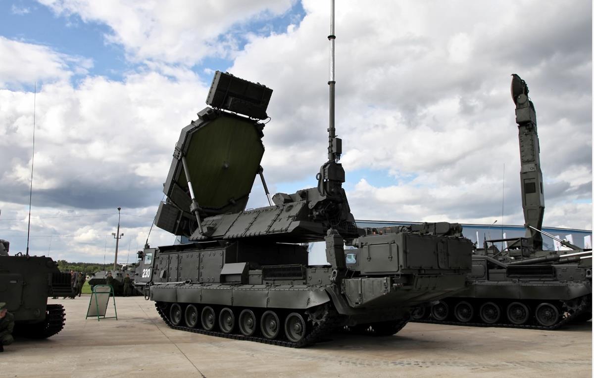
(4) Wikipedia, Datei:S-300V - 9S32 Einsatzradar - hinteres view.jpg
Text - Quellenangaben
[1] Wikimapia.org / Militär
[1] Wikimapia
[2] Wikipedia, Logo
[3] Wikipedia, AN/FPS-117
[4] Wikipedia, AN/TPS-77
[5] Wikipedia, Plessey AR-320 (AR-327)
"ace-high-journal.de" - alle Rechte bei WebMaster - Online seit 01.01.2009